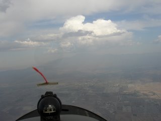
A storm front went through SoCal on Saturday, and the Sunday forecast looked like there might be some lift. The forecast temperature gradient indicated no inversion, the air was cold aloft, the satellite showed less than 50% cloud cover, and I suspected the ground temp might exceed the trigger temp. So I went to the field hoping for the best. The CU were indeed scattered, and staying in one place, which made me think there was lift working. The tow pilot said there was lift right under the clouds, so I decided to go.
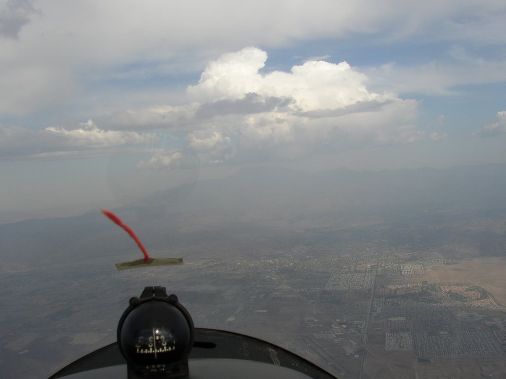
Due to a few delays, I didn't take off until 3:00. At 3700' AGL we were going up at 10kts or more, and getting close to the clouds, so I released. I found a little weak lift or zero sink and floated around under a dark CU. Then I noticed a 2-33 coming toward me WAY higher - right below the cloudbase... so I wished I had held on a little longer. I never did find much under that cloud. At one point there were two 2-33's and me trying to work that cloud. Headed for another one that was obviously building, but it was too far away. I tried to get under a little wisp that looked concave on the bottom, indicating lift, but it wasn't enough. Quite a bit of weak sink all around. I noticed that the Speed to Fly indicator on the Borgelt was not making sense according to the lift and sink, and I found that it was sticking! Maybe because of the cold? SOmething to watch out for in the future.
I ended up heading for the Initial Point. I got into some sink on the 45-degree leg, then lighter sink on downwind... only about 600' AGL abeam the runway. I normally don't look at the altimeter in the pattern, but since there was sink I kept an eye on it. It turned out OK - the rest of downwind was zero sink, so I ended up right where I needed to be on base. I had a really good, smooth landing, which is encouraging. My last two have been very good, after a string of bump-downs.
I was hoping for a clear view of the snow on the mountains after yesterday's storm, but the remaining clouds obscured much of the white stuff.
So... a sled ride is better than nothing!
Sunday, December 17, 2006
Wednesday, December 13, 2006
National Geographic from 1967
One of my first exposures to soaring was an article in National Geographic magazine. I used to read them cover to cover when I was a kid (still do, pretty much). After I got into soaring just a few years ago, I recalled that article and hoped to see it again someday. Well, a fellow has just finished posting it to his web site, pictures and diagrams and all. It's a wonderful introduction to soaring! I highly recommend it to anyone even remotely interested... it'll give you a real sense of what it's all about and just how fun and unique it is. I'm putting this article on my permanent links. To anyone just discovering my blog: go read this, then come back here inspired.
It's from 1967, 40 years ago... but so much of it is still true. Sure, the high-end ships are all fiberglass or composite now... and we fly with GPS and lots of other electronics to make it safer. But you know, there are still a bunch of old Schweizer 1-26 and 2-33 gliders at my home field. And I learned to fly in a metal ship, the Blanik L-13. The thrill of one's first solo - and one's first flight alongside a raptor - is exactly the same as the article describes!
It's from 1967, 40 years ago... but so much of it is still true. Sure, the high-end ships are all fiberglass or composite now... and we fly with GPS and lots of other electronics to make it safer. But you know, there are still a bunch of old Schweizer 1-26 and 2-33 gliders at my home field. And I learned to fly in a metal ship, the Blanik L-13. The thrill of one's first solo - and one's first flight alongside a raptor - is exactly the same as the article describes!
Friday, December 08, 2006
eFlyBook
In the current issues of aviation magazines, there are ads for eFlyBook. This device contains various flight documents for power pilots, but the interesting part is the use of a "digital paper" display. Other than retail store signs, this is the first commercial use of digital paper that I have seen. Digital paper is a technology that uses tiny rotating beads, black on one side and white on the other, electrostatically rotated, forming a non-volatile, non-luminous display. The upside is that it is clearly visible in full sunlight! The downside is that right now DP is limited to monochrome. I am hoping that the PDA makers will someday produce a DP-based unit, which might eventually be useful with SeeYouMobile, WinPilot and the like. It's really hard to see the display on my HP IPAQ in the cockpit, even though the one I selected was recommended as one of the most visible. I did some searching and did not find any hints of such a product yet.
Friday, November 24, 2006
Passenger flight
Friends were in town for Thanksgiving, and one wanted to go for a flight. So we headed out today. Since it was a Friday, there were very few people at the gliderport... just one other from my club. We took off in a Blanik L13 at 10:40. We intentionally went early to have smooth air, since this was Mark's first time in any small aircraft. I've learned from taking other passengers that it's best to take it really easy - no thermaling, 'cuz the circling can make people airsick if they're not used to it. And it certainly was smooth. Not even a hint of lift until we were back down to about 1200' AGL, and then it wasn't even zero sink, not enough to sustain us.
Mark had a great time, looking around at the mountains and lakes and taking pictures. We took a 4000' tow since we knew there would be no lift. It was pretty hazy at ground level, but clear above about 2500' AGL. No other gliders aloft, no birds... a couple of power planes well below us. Mark was fine with the flying and turning, so I circled once or twice just as we were at the Initial Point, no more than about 35 degrees of bank. Later he said that was his favorite part! So he probably would have been fine with thermaling, but you never know.
I flew from the rear seat, which I have not done for quite a while. In the Blanik, it's really quite easy to fly from there - the visibility is great. And this particular ship flies really nice. It just came out of annual, and it's really smooth. (I noticed I was a little high on early tow, fighting to keep down with the towplane. Trimming farther forward took care of that problem.) Later, I flew hands-off for a while, and it stayed perfectly on pitch and stayed wings-level for probably 15-20 seconds. We ended up with a 24-minute flight, a little less than I expected. I focused on my landing, since I've had a few rough ones lately. I spotted my aiming point better, kept my speed up through the flare, and had a very smooth two-point touchdown and short rollout. Very nice!
Tuesday, November 21, 2006
Stable
Saturday, November 18, 2006
Although the ground temperature got pretty warm today, high 90's, the temperature aloft was too warm to to allow thermals to develop. It was just plain stable all day. None of the club private pilots flew at all. Only the students took flights... and none of them found any lift.
There's this one guy with a private ship... not part of a club. P7 takes off early and stays away all day, when no one else can do anything. I don't know how he does it.
On the plus side, I spent some time working with the club's Volkslogger in the PW-5 and was finally able to get it to send live data to SeeYou Mobile on my IPAQ. (I got an email from the Volkslogger tech support group with the connection info. The VL uses a different baud rate for upload/download mode than it does for flight mode - I never would have figured that out.) I'm anxious to see how flights logged that way differ from flights recorded with my Transplant GPS unit. Based on some ground testing, I suspect my traces so far are off by a couple hundred feet, consistently to one side. I don't know if it's the Transplant or the SeeYou... the test with the VL feed will tell me.
Saturday, November 04, 2006
Staying high
One of our club members recently accomplished a 300 kilometer flight in our PW5. Today we were talking about it, and he related something that I too have felt after my best flights. The feeling of elation and accomplishment stays with you for up to a couple of weeks. After my first solo, my first 10,000' flight, my practical test, and my first cross-country flight, I just did not come down for many days. I kept reliving the flight and felt very excited every time I thought about it. I don't think non-pilots quite understand how thrilling and satisfying it is to accomplish a new flying milestone. But I know my wife has noticed it on a couple of occasions 'cuz she's mentioned it to others.
I think that's partly why I started this blog. I just felt that I needed to write about soaring and share it with whoever would listen... and family and friends can only listen so much. ;-)
Comments welcome! I get very few comments on my blog entries these days... maybe no one's reading. But I'll keep writing.
Thermal forecast spreadsheet
A few months ago I created an Excel spreadsheet to produce the standard thermal forecast chart. In training you learn how to take the forecast high temperature on the ground and the standard lapse rate, compare it to the forecast "soundings" at 3,000' intervals, and calculate a probable maximum thermal height and thermal index. This gets tedious, and would take a lot of time in the morning when preparing for a day of soaring. There are various resources on the web that present this information in one way or another, but not in an easy-to-take-along format.
So, being a computer programmer, I naturally thought of automating it. And since I thought others might want to use it, I wanted a platform that could be easily shared. I decided that Microsoft Excel would be suitable - especially since it has graphing capabilities. It took me a couple of days to work it out, and a couple of versions to get the bugs out. I offered it to people on my club's mailing list and a few took me up on it.
The NWS does not prepare a sounding forecast for Hemet. The closest ones available are for Miramar NAS near San Diego and for Ontario. They're about equidistant from Hemet, and I think the Miramar forecast would have too much ocean influence, so I built my program to use both and calculate an average. It seems to work pretty well. I still use it, every soaring day.
One thing I learned is that just a few degrees of difference at the ground level can cause a huge difference in thermal height. There's a "trigger temperature" at which thermal production should start. Often the forecast maximum ground level temperature is close to the trigger temp, which would mean little or no lift. Just a few more degrees means that the thermals can go thousands of feet higher. Playing with the spreadsheet really shows this. I've always looked at a lot of weather info on each soaring day, and one thing I've noticed is that the forecast temps for Hemet are almost always lower than the maximum we see at the airport. I look at the newspaper (I don't know their source), and Weather Underground, and the NWS. They're all low a lot of the time. Today the forecast was 76F to 78F, and the actual high on our thermometer (4 ft from ground level, in the shade, out of the wind) was 87F.
So I've learned to be a little more optimistic than my thermal forecast indicates.
I don't think there's any way to upload files to this blog site. If anyone wants a copy of my graphing thermal forecast spreadsheet, please reply to this post with your email address, and I'll send it to you. It is not totally generic, it's specific for our field's 1500' MSL altitude. If you want to work with a different field elevation, you'd have to study and adjust some formulas.
A short flight
The weather was sunny and warm with a few high cirrus. The forecast high for Hemet was 76F, and because the forecast soundings were pretty warm that would have meant poor or no lift. Fortunately it was much warmer, about 87F by about 1:30. There were enough thermals for a few folks to get 1 to 1.5 hour flights. I got 39 minutes. Although I found a couple of thermals, they only averaged about 1.5 kt and I could not get above 3500' AGL.
I shared a thermal with one of the commercial Schweitzer 2-33's. Neither of us went up very much. They ended up returning right at the same time I did - I adjusted my pattern a bit to avoid them. Wouldn't you know, I found weak lift on downwind. They were way low and I was way high!
I'm still having an issue with landings. I think I've figured out part of it. I think I'm coming down a little too steeply and rounding out too early, which puts me too far from the landing area. Then I end up closing spoilers a bit - I know not to stretch the glide with elevator! But I do end up slow at just about 1 foot off the ground, and setting down hard as it stalls out. I think I need to pull my base leg closer to the runway so I can keep the spoilers and glide slope about the same, and round out later.
Tuesday, October 17, 2006
Aviation magazines I read
In rough order of preference:
- Soaring of course
- AOPA Pilot lots of great articles, occasional soaring exposure
- Flight Training also by AOPA, very high quality
- FAA Aviation News I bet not many glider pilots know about this one. Good info, poorly edited.
- Flying pretty good - but never anything about soaring
Sunday, October 08, 2006
Nice flight, learning Volkslogger
Today I got a nice 2 hour and 22 minute flight. The forecast was for cold air aloft, and about 86F on the ground, which sounded good for instability. The wind stayed away, and there were lots of small-to-medium CU clouds. Not much lift until about 1:30... some of the early glass ships came back down pretty quickly.
I took off in the PW5 at 2:00 and by then lift was plentiful all over the Hemet valley. I let off at 4600', found lift up to about 6400', and made it over to the "S" ridge. But that area was pretty much shaded by the clouds, and the small area of the slope that was sunny was not working, so I headed back. I found decent lift over town, mostly over a parking lot, and worked my way back up. Then I headed west and joined WO in a nice thermal up to about 6800' again. That took me nearly up to some solid clouds, so I headed toward them. Sure enough, the "cloud suck" was working. The thermal lift turned into a pretty big shear line marked by irregular but fairly distinct clouds. That worked really well - I spent a lot of time between 6000' and 7500', up and down. I practiced working the shear without much circling. I headed further southwest than I have before, nearly to the I-215 in the Menifee area. But the wind was from the northwest, so I didn't want to head too far south.
I encountered a hawk, and what I think was a falcon. He was darker, sleeker, and moving faster than the hawks usually do. I also spotted a bunch of hang gliders and paragliders, but they were very close to the ground and not thermaling. I spent some time sharing a thermal with a 2-33 and later a PW6.
I also tried some hands-off flight to see how the PW5 would maintain speed. It did pretty well, hunting up and down by about 5-7 knots around the trimmed speed. It might have been diverging... maybe I'll try it again some day and see if it is stable or unstable. Laterally it was fairly stable. I was able to keep wings level with minor rudder adjustments.
Some other gliders were reporting rain and lightning near Idyllwild, and the clouds over Mt. San Jacinto were spreading out and getting very gray. So I eventually put on the airbrakes and descended from 5500' down to pattern altitude of 2500'. It seems a shame to waste altitude like this when I fought all winter for it! But this summer and fall it seems that 2-hour-plus flights are getting easier and easier. (I was not tired at all, though my back had a couple of twinges.)
Before the flight I installed the club's Volkslogger and tried hooking it to my PDA with the cable that JS provided. The instructions for ConnectMe worked perfectly. I was able to create my pilot and ship info, upload it to the VL, and download flights from the VL to the PDA. Then I tried using SeeYou with the VL, and could not establish a connection. Seems that ConnectMe uses all the right serial port connections but diesn't tell you what they all are (just portname and baud rate). SeeYou lets you set (therefore you need to set) bits, parity, and signals... but what should they be for the VL? Defaults did not work. I didn't want to spend any more time on the ground, so I skipped that part for today, opting to use my plug-in GPS unit. But after the flight I was again able to download the flight files with ConnectMe. So I'm halfway there!
Saturday, September 16, 2006
Contest
Our club ran an internal contest today. Each flight competes for duration, distance, altitude gain, timing, and spot landing. To keep it fun for all, students can participate because they can fly with an instructor. This was my first time.
Soaring conditions were not forecast to be great. So the timed goal was a 30-minute flight: whoever comes closest to 30 minutes, from start of takeoff roll to first touchdown, wins. Since a "sled ride" from 3000' takes about 17 minutes, some soaring would be necessary. The spot landing involves stopping coming as close as possible to a cone (measured from the nose of the plane) without going past.
Some people found decent lift and got altitude gains of 2000 and 2700 feet. I never got above my release altitude. No one went very far from the airport, so the distance part will not be so hot.
My flight was 28 minutes and 30 seconds. At least two people were even closer. My landing was 7 feet from the cone and again, at least two were better. Lots of people rolled past the target.
The timed flight was interesting, since I had not tried to do that before. I estimated how long the pattern and landing would take, worked backward to what time I needed to enter the pattern, then arranged to bleed off altitude so I entered the pattern at the right time and the right altitude. Not too hard. But I overestimated how long the pattern would take. I guessed 4 minutes, and it was more like 2.5.
Thursday, September 14, 2006
Thinking about my first XC flight
I know it wasn't a very long flight, as cross-country flights go: about 62 miles round trip. And I know many glider pilots start XC much earlier in their flying careers. And I know it was a really easy day to fly, because of the excellent conditions. But in some ways that first flight away from the airport - farther than I could glide back - was just as exciting as my first solo flight, my first 10,000' flight, and getting my private certificate.
Right now I'm flying in an MD80 from Montreal to Chicago, and reading a little book about using imagination to shoot for far-reaching goals. Below us is an unbroken flat deck of clouds as far as I can see in all directions. Such a flight is obviously completely dependent on navigational instruments: GPS, VOR, compass, who knows what else. It somehow made me think of my flight northward from Cache Peak toward Walker Pass, over terrain I'd never seen before, partly guided by the "task" line on my GPS... but also guided by the planning and thinking I had done before the flight.... unable to see the airport from which I had come. A cross-country flight, knowing I need to use all my skills to find lift to get me home, is a big step and an exciting one.
I'd been planning for it, training for it, and I finally did it. I know I'll go on to more distant and more difficult flights, but I'll remember this one for a long time.
I think every glider pilot should be proud of what they've learned. I did the math once, and I estimate that only about 1 in 10,000 people in the U.S. can do what we do!
Sunday, September 03, 2006
First true cross-country flight!
The club is on a weekend campout to Mountain Valley Airport in Tehachapi. Yesterday I had a 1.5 hour flight in the PW5, my first time flying solo at Tehachapi and my first time flying the PW5 anywhere but Hemet. Good strong lift under CU clouds. I got to 12,800 MSL, my highest ever. I did not leave the valley area, because I had not done enough planning yet, and because H was to fly the ship after me. I ended up with 1:35 total. Strong day! Lots of ships following obvious cloud streets to the north.
Today L gave some of us some route and waypoint and landout site pointers using the relief map wall. I plugged some informal goal points into my GPS database. The weather was just as good as yesterday! H flew first and got to 12,500 easily. Because of timing, equipment (Volkslogger was left at Hemet) and not wanting to push too far, I did not declare the flight. But I had Silver requirements in mind.
I found good lift on tow at 3000' AGL but was lower over the Tehachapi mts than I liked. So I held on and  again got good lift at 4000' AGL. That thermal took me up to over 12K MSL. I followed my plan and followed decent lift under CU along the ridges at the east end of the valley. When I found lift over Cache Peak (already the farthest I'd been from MVA) I knew I was on my way.
I followed the cloud street, between 12K and 13K, along the east side of Kelso Valley. At one point I was down to 8500 MSL and had to backtrack to lift. I found the Rockpile and a good house thermal. I rode that up to over 14K and fairly near the clouds. That enabled me to head north toward Walker Pass. I got about halfway there and decided to turn back due to lack of lift.
Back at the Rockpile I found the same thermal. Looking up I saw a glider circling about 3000' above me. I took that one all the way up to 15,100 MSL (just 500' under the clouds), my highest ever! Rather than try Walker again, I set up for a long final glide back to MVA.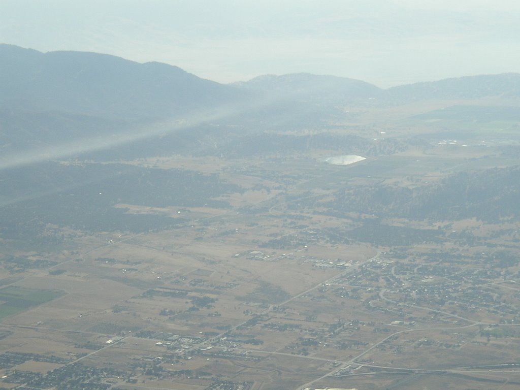 All the way southbound, I was in nearly zero sink. Very smooth. I had time to play with airspeeds and resulting L/D, comparing the speed-to-fly recommendations of my GPS and the Borgelt in the ship. When I got back to the Tehachapi valley I had about 5000' to spare! After burning up that altitude I ended up with a 2:17 total time.
The only bad part was that my landing was not great. I got a little off on my direction while floating in ground effect, didn't notice my airspeed while correcting, and stalled it at about 1-2 feet, landing with a thump. Rollout was kind of wandering, due to a bit of crosswind and the small rudder of the PW5. But I ended up rolling off in just the right place.
Reviewing my map and GPS navigation, it looks like a 31.2 nm distance - just over Silver distance! And certainly my altitude gain was over Silver, too. So if I'd declared it, I'd be 2/3 of the way there!
Not bad for a first XC venture.
Saturday, August 19, 2006
Blown out, sort of
Today the forecast was for pretty good lift, and I was planning to fly the PW5. The club had some work to do, and a general meeting, and a lunch, and other stuff to do, so I wasn't ready to go until about 2:30. The wind picked up to a fairly constant 13 to 15 kts, more than the NWS or DUATS had predicted. I would be OK with the wind, but no one was staying up because the thermals were getting shredded and there was a fairly strong inversion. Instructor came back down and said that they had found no lift at all in two flights. So I decided not to spend $60 on a sled ride.
J and L took off in the Blanik just a few minutes before I would have, and they ended up getting at least an hour flight. It turns out that a shear line, which I had been seeing in the distance all early afternoon, worked its way into the valley and they were able to fly it over to the "S" ridge and back. I probably could have too... I've used convergence lift before and this one was quite visible (the Serengeti sunglasses help a lot). So by 3:30 I was kicking myself for not having gone up. I should have trusted my instincts and gone up even though the wind was blowing out the thermals - that shear line was really obvious.
I finally got my PDA / GPS system working again. It seems that one of the airspace files I use was corrupt or at least causing SeeYou to crash. I went back to a smaller airspace file and now it's working fine.
Next opportunity: club trip to Tehachapi over Labor Day weekend. We'll take a Blanik and the PW5.
Saturday, August 05, 2006
Bronze Badge
Today I received my SSA Bronze Badge after completing the last of the requirements. For anyone not familiar with the badge system:
- The SSA awards the A, B, C, and Bronze badges for successive levels of soaring accomplishments.
- The FAI awards the Silver, Gold, and Diamond badges
The Bronze Badge is supposed to signify that one is qualified and prepared for cross-country flights. The requirements for the Bronze Badge are:
- Have received the C badge
- 15 solo hours in gliders, including 30 solo flights
- 2 solo flights of 2 hours each
- 3 solo spot landings
- 2 dual spot landings with instructor with no reference to altimeter
- Pass the written exam with at least 80% correct
Our club ran a Bronze Badge / Cross Country workshop last winter and then administered the Bronze written test. I had already fulfilled most of the solo time and flight requirements, but still needed the duration and no-altimeter spot landings. All last summer and winter I seemed to have bad luck with the thermals. But I finally completed the 2-hour flights in June (see "Longest Flight So Far") and July ("Booming day! Best flight yet").
Today I completed the two no-altimeter spot landings. That's really not an issue - I've been in the habit of doing the whole pattern by visual angle estimation for a long time. I never look at the altimeter in the pattern, and don't always use the vario either. The first time I consciously did a no-altimeter landing was as a surprise requirement of the last flight of my Practical Test.
I was never very motivated by the A, B, and C badges. At the time I was much more interested in getting my Private Pilot certificate. But the Bronze seemed a bit more significant, and I'm rather proud of that tiny metal pin.
I'm now looking ahead to the Silver... I've already exceeded the required altitude gain a number of times, but I've never recorded it on a barograph or logger. So that's my next step. The distance goal will be a little tougher, and I've been doing a bit of planning for my first true cross-country flights.
Friday, July 28, 2006
Minden, Nevada
 Tuesday 7/25: We've been camping at Lake Tahoe, just a short distance from Minden, NV, so I made arrangements with Soar Minden. Weather has been great for soaring: hot and lots of moisture to form CU. I got checked out in Grob 103 (different model from my club's) by instructor 1. I'd been having stomach problems all morning and was feeling kind of shaky and "off". We took a 2000' tow. My takeoff wasn't the best - strayed off to the left before recovering. The tug looked to be a Pawnee, took us up at about 600 fpm. This ship has a turn&bank indicator, the first I've seen. (I didn't really use it, but every time I looked it was centered. It reacts much slower than the yaw string.) The radio has a speaker, so no need for a headset, but it's hard to hear. There's a temporary tower due to fire ops, and this is my first experience with ATC. (Fortunately the controllers are nice - one of them is taking glider training!) Long asphalt runway for landing - I have not landed on asphalt very much. One of my O2 connectors fit, thanks to my quick-connect setup, so I'll be able to use my own cannula and hose! The instructor commented that I lean to the left when flying - others have noticed that too, so I work on it when I remember. It's only 11:00 but there's slight thermal activity.
Their pattern starts at 1300 agl over IP - quite high, so lots of airbrake on the base and final. My airspeed was just a little high at 60 kt on final. Flared high. Touchdown good. Instructor took over to taxi to staging area. He signed off after one flight.
I broke for lunch, got set to fly solo at about 13:30. But my stomach issues were not over, so I cancelled my flight and decided to come back another day. The owner isn't satisfied, says the checkout was not thorough enough, should have included a rope break or something else. When I come back I need to work with an instructor again. That's a bummer... can't just show up and fly some afternoon. And this is going to get expensive. But... they're his aircraft, not mine. And he's fair about the costs, only charging for fractions of hours where appropriate.
Area notes: cold air from Tahoe spills over mountains / down canyons, causing heavy sink below ridge. Pine Nut mtns not steep enough for true ridge soaring. Possible to thermal up high enough to get above mtns and see Tahoe. Forecast is 1100+
Thursday 7/29: checked out again with instructor 2. Solid takeoff this time. 17 min flight, some thermaling. More thorough ground tour of runways, taxiways etc. 2 is thoroughly happy with my flight, especially my semi-slipping turn to final, although I still flared a bit high and touched down a little firm. I just need to take more time to let the Grob bleed off its speed and altitude - don't rush the stick back.
Unfortunately my PDA/GPS locked up as we were getting ready, and would not restart. I think it simply overheated in the sun. I worked on it during lunch, got it to restart but had to reload all the software and files from SD memory card, and my waypoints file won't load. So I have to fly without it. Not a show-stopper, but I'd like to have a flight trace, and it also makes safe gliding distance calculation so much easier!
So I took off at 14:02 and released in strong lift at 2500' AGL. I found very strong thermals right away in an area that had been recommended. 8 to 10 kts up, even above 9000' MSL! Pretty turbulent thermals, too. But around the lift is a LOT of sink. I'm not sure I'd ever seen 10 sink before - but there was plenty of 6 to 10 down! FS had recommended using a glide ratio of 20:1 for cross-country calculation... D had also said to be very conservative. They were right! I went up to 11,500 MSL (new personal record). I could see much of Lake Tahoe, Carson City, Reno, and smoke from a brush fire near Virginia City. I took a bunch of pictures, which at this point is not very easy for me while thermaling. From 11,000 I started to head to the next ridge of hills, to try to stairstep up to Mineral Peak, but every time I headed east I hit sink and needed to head back to maintain final glide distance to the airport. No way I want to land out in a rented ship!
 Thermal Hill just north of the airport lived up to its name, taking me back up to 10,200. I tried to head west across the valley toward the Sierras, but the briefings had not been very encouraging about finding lift on that side. I hit sink right away and quickly lost over 1000'. I headed back to Thermal Hill and the Sand Pits and worked back up to about 9000'. At one point I think I found a shear line, which took me up at 4 kts while flying straight ahead! By now it was about an hour and a half of flying, and E had called once, and I was not up to trying to go any distance again. So I just flew around east of the airport, up and down a bit. Lots of minor lift, so I wasn't coming down fast at all. I finally found some mild sink to circle in, over some circular irrigated field, and came down at 1 hour and 58 minutes. I don't think I ever got more that about 7 miles from MEV.
Lake Tahoe visible over the first ridge.
The temporary tower was gone today, so no ATC to deal with. Hard to get a good look at windsocks or wind "T", but it was obvious from my drift and from AWOS that the wind had picked up out of the west. Crosswind landing on runway 30 went well. Long taxi right into the parking area, although as 2 predicted, it gets hard to steer when you get slow and with a crosswind.
New/best experiences:
+ First time at an airport with intersecting runways
+ First time interacting with ATC
+ First use of oxygen
+ Strongest lift I've ever found!
- Strongest sink I've ever found!
+ First use of turn&bank indicator (ball).
So although I never went cross-country, it was still a good experience flying in a new location with very strong conditions.
Saturday, July 08, 2006
Booming day! Best flight yet!
The forecast was awesome: 1143 fpm to 15,000'. I've learned to take these with a grain of salt, but the trigger temp was 82 and the forecast high 102. This week has seen CuNim in the mountains, but they've been settling down. So it sounded good. A and K flew the Grob before me, about 12:00, and got an hour+, getting up to 9000' or so. Others were up to 11,300'. I planned to try for the "S" ridge and beyond, if possible (I've only been there once), and if not, then repeat my XC practice triangle and try for my second 2-hour flight. I planned to take all my gear along, to practice XC conditions. But my oxygen tube had a leak, so I left it out. Temp on the ground was 106.
From the ground we could see a clear shear line due to the different colors of the air masses. Just before I took off, it started forming some tiny CU. Over the mountains, it still did not look overdeveloped, although some reported rain. It did not look dangerously strong.
I took off at 13:55. Good lift on tow, I let off at 4500' MSL and found a little lift right away over the low hills. After a couple turns, I spotted a huge dust devil down in the valley - big, but the dust only going up about 300'. I found great lift over it and rode it all the way up to about 9000'! The wind drifted me partway to the S ridge, so off I went.
I made my way over toward Mt. San Jacinto and started working thermal and orographic lift. Nice lift kept taking me up toward the clouds. I worked it up to over 10,000' a couple of times. One time I went right up a ridge, using what must have been anabatic winds. Max alt according to my GPS was 11,000. A couple of times I felt the lift was getting pretty strong (but no more than 800fpm) right under the clouds so I headed out from under the weak "anvil" formation and into clearer sky. Whenever I found sink, I turned away from the peaks and headed down the valley until I found lift again. My GPS always indicated that I was way above the required glideslope to reach Hemet, so I was always safe. It also indicated 3000'-4000' above ground level at all times. Great practice for the Sierras when I go to Minden in a couple weeks.
I could see over to the windmills along I-10... I could see Hemet Lake but did not go that far. At one point I was exactly even with the top of the peak but still some distance from it (later measured as 3.75nm away). I estimated that to try to get on top of the peak would put me too close to cloudbase, and I got sprinkled on one time, and from under the cloud I could not tell if it was overdeveloping. So I never reached the peak.
Fun stuff along the way:
- A paraglider at least 3000' higher than me (when I was still over the valley)
- A hawk above me at about 9000'
- A CDF firebomber passing at least 3000' below me
Un-fun stuff:
- Radio not transmitting. I think I had the push-to-talk button wired in wrong. Fumbled around with it while thermaling left-handed. Gave up, pulled the plug, and pressed the handheld PTT when necessary.
- Taking pictures. I've resisted taking along my camera, not wanting the distraction. But I need to learn to take turnpoint pictures. That's hard... my scenic pics came out but my turnpoint shots did not.
Eventually, with about 10,000' in the bank, I headed across the valley toward Diamond Valley Lake. I've skirted it before but never gone beyond it (partly because it's usually downwind of home). This time I had enough altitude (and favorable winds) to go across it and over to (what I now know is) Lake Skinner. I could see all the way to the Palomar observatory! I also spotted French Valley airport.
Still lots of altitude... head northeast past the dams to see if there's more lift on the way back. Ah yes, the shearline! I'd heard guys on the radio using the shearline/cloud street to go across the valley. By now, those little CU's were nicely formed, clearly pointing out the line. Once I got in it, I had 600 to 800fpm to take me back to the valley - without even circling!
Back to the IP area, more than two hours logged, and still 3000' excess altitude. So I did a couple of stalls, then eventually pulled the spoilers just to lose altitude. (The pre-stall buffet in the Grob was VERY rough and noisy - I've never heard anything like it!) Pattern entry was weird... just as I turned the to the 45 leg, my yaw string was way off to the right although I was turning and ruddering left. I think it might have been stalling and falling off... maybe caught a gust? I nosed over and ruddered harder and it straightened out. Definitely something to watch out for. Landing was fine. Back on the ground, it was 106F again... and no one else from the club left at the field. With the wingwheel, I can push the Grob by myself, but it's pretty tough.
Net result: my best flight ever!
- Longest: 2 hours 24 minutes
- Highest solo: 11,000' MSL
- Farthest: 15.7nm straight-line distance from the airport (that doesn't sound like much now that I say it), 65.6nm total distance
That's the second of the two 2-hour flights I need for my Bronze badge.
Wednesday, July 05, 2006
Planning for Minden
I'll be in the Tahoe area in late July, so I'm planning to fly at Minden one day (more if I can work it out). So I'm doing some planning and preparation:
- Soar Minden has some great on-line prep material. I've read it and need to study it in more detail.
- I've previewed the area in Google Earth to get an idea of the terrain.
- I ordered a sectional chart of the area. It just arrived today, so I need to spend some time with it.
- I've flown Sailors of the Sky a number of times, and it's based on Minden (at least the basic map that comes with it is). In the past, I just used it for basic soaring, spin, and landing practice, never paying attention to the terrain. Recently I've done a couple of sim flights looking to go places. It's useful to get some idea of the mountain heights and distances, but the terrain graphics are not all that great, so it's not good for familiarization. GE is more helpful. I may try it again.
- I've emailed SM to start talking about what kind of instruction and field checkout I should get.
Since I have just a few hours in mountain soaring (to 12,300' over Tehachapi) and never solo in high terrain, I may end up just getting instruction and maybe soaring over the valley. We'll have to see.
Any readers have any advice or feedback about Minden and the mountains?
Sunday, June 11, 2006
Two so-so flights
The forecast was for 261 to 4650' if it heated up to the trigger temp of 81. Forecast highs ranged from 78 to 80. There was to be an inversion, but weaker than it usually is. See last week's blog... if the temp exceeds the trigger temp even a little, I'm hoping for some thermal activity. As I drove out, weather reports were showing about 81 to 82.
I got to the field later than I had planned, and took off about 2:15 in the PW-5. It was Sunday, and although I didn't expect many club members to be out, I thought some might be since the airport was closed for an air show on Saturday. Nope, no one else there. But the PW5 is light enough to push out by myself. Well, I did get another guy to help since the wind was a little gusty. He reported a little lift but not very long flights in their PW-6.
First flight I found a few bumps, no major sink. Some turbulence - I think the wind was knocking down the thermals. But there were some hints, and the day was so nice I couldn't just settle for a 19-minute sled ride.
So I went right up again. By now it's 3:22. Again I glided around without finding much. I tried over a burned area, thinking the black ground might be working - no luck. But just a few hundred feet from the pattern altitude, I found a weak thermal, averaging maybe 1.5 to 2 knots. It took a while but I got about 900' out of it (max altitude probably 3900'). Not quite as high as the NWS and I forecast, but it was better than nothing! I couldn't find any more, so I finished up with a 38-minute flight.
Sunday, June 04, 2006
Trigger temperature
Yesterday's lift was much better than the NWS forecast and my forecast spreadsheet indicated. Based on a max temp forecast of 100F, my spreadsheet had indicated that the thermal temperature would be very close to the lapse rate temp all the way up, with a soaring index of only -1. The NWS forecast only 126 fpm lift @ 5000' MSL and a trigger temp of 132 F.
But the actual high at Hemet as measured by our thermometer was 106F when I took off and 109F when I landed. So I went back to my spreadsheet and plugged in 106: that changes the thermal index to -4 @ 5000. 109 takes it to -6. Much better! With just a few degrees additional heating, the thermal line pulls away from the ambient line quite a bit. And my trigger temp calculation was 98F, vs. 132 by the NWS. So... I need to look into trigger temp calculations and see how the NWS and I differ. 109-98=11 degrees, clearly over the trigger. And thermals were definitely being triggered... all over the place!
So what did I learn? If my forecast indicates the trigger temp is near the max forecast temp, try a few different temperatures and see how the lift forecast changes. Then I'll be prepared to evaluate the lift possibility as the day's actual temperature progresses.
Saturday, June 03, 2006
Longest flight so far!
Today the soaring forecast was dismal: 150 fpm, due to very warm air aloft and a 5000' thick inversion. But the forecast turned out to be wrong. The ground temperature cranked up to 106 degrees, and apparently that was enough to punch through the inversion, or it lifted, or something. Some of us were able to get up over 6000' MSL. I found 2-4 kt lift all over the Hemet valley!
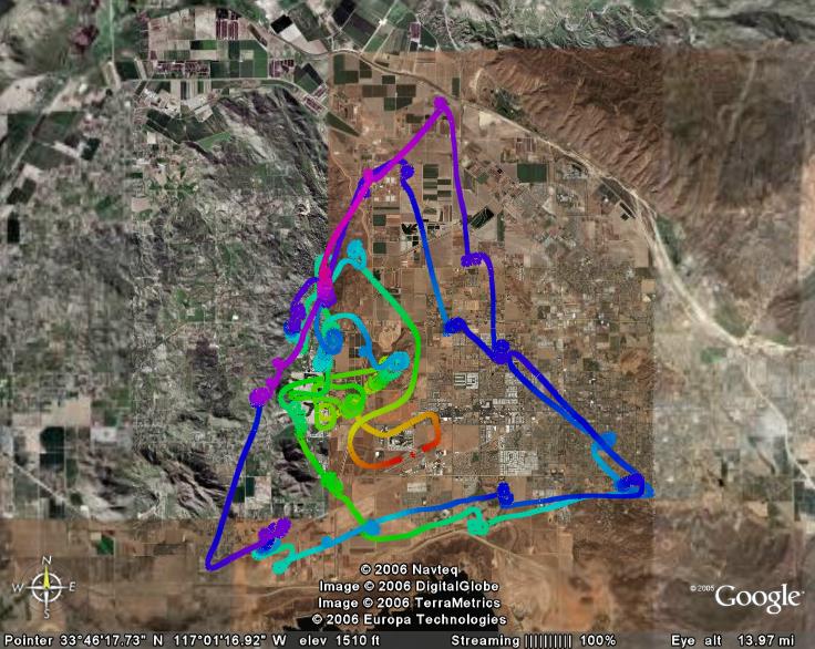
I was able to complete the "cross-country practice triangle" that I've been working on. It's three legs of about 16-17 mile each, but centered on the HMT gliderport so you're never too far away. I found lift two or three times on each leg, so it pretty well simulated the requirements of a cross-country flight. I did it one and 2/3 times, for a total of about 80 linear miles. Her's the flight trace:

This was one of the few flights I've had where I got high right away and then was able to stay within a lift band, so I was rarely desperate for altitude. Thermals were plentiful enough that I could finally spend some time practicing different centering and searching techniques I've been studying... usually I'm scratching for any lift I can find.
I was almost done at about 1:45... so close to the two hours! But near the airport, with about 200' to go before having to enter the pattern, I found a decent thermal that took me back up to 4500' or so, taking me to the 2-hour mark. I used up all my water and was getting pretty hot and tired, so I brought it down for a 2:17 total. That's one of the two 2-hour flights I need for my Bronze badge!
I intentionally took the Grob so I could get current in it again. I will probably take some passengers up soon, and wanted to be safe in it. No problem - I really enjoy flying it, although it does take a LOT of rudder rolling into turns. I think the long wings make it easier to catch thermals than in the little PW5.
I was able to complete the "cross-country practice triangle" that I've been working on. It's three legs of about 16-17 mile each, but centered on the HMT gliderport so you're never too far away. I found lift two or three times on each leg, so it pretty well simulated the requirements of a cross-country flight. I did it one and 2/3 times, for a total of about 80 linear miles. Her's the flight trace:
This was one of the few flights I've had where I got high right away and then was able to stay within a lift band, so I was rarely desperate for altitude. Thermals were plentiful enough that I could finally spend some time practicing different centering and searching techniques I've been studying... usually I'm scratching for any lift I can find.
I was almost done at about 1:45... so close to the two hours! But near the airport, with about 200' to go before having to enter the pattern, I found a decent thermal that took me back up to 4500' or so, taking me to the 2-hour mark. I used up all my water and was getting pretty hot and tired, so I brought it down for a 2:17 total. That's one of the two 2-hour flights I need for my Bronze badge!
I intentionally took the Grob so I could get current in it again. I will probably take some passengers up soon, and wanted to be safe in it. No problem - I really enjoy flying it, although it does take a LOT of rudder rolling into turns. I think the long wings make it easier to catch thermals than in the little PW5.
Saturday, May 13, 2006
Every flight is different
The forecast soaring index was OK, 5kt to 7500'. The weather looked iffy, though: 90 degrees, an inversion, some cirrus, light wind at about 4kt. I took off in the PW-5 at about 2:30 not expecting much.
The tow was really weird. Very early on, it seemed as if I could not get the glider to get up to the high tow position. I pulled up and the nose was high enough I could barely see the towplane, but it wouldn't get up. I checked the spoilers - no problem. When I'd nose back down to see the towplane I'd get slack. After just a few seconds, still going straight out from the runway, suddenly we were at 800' AGL. I felt like I was PIO'ing a bit, but not bad. Finally I got the glider into a decent position, and it was bumpy but not as bad as I've felt before.
We were climbing sometimes 8 to 10kt. Up at about 2000' AGL I again had trouble with nose-high attitude and getting slack in the line. I almost released because I was briefly unable to see the towplane, but a bit of yaw took out slack and got it back to normal. At about 3000' AGL I didn't like the climb rate so I held out for a while, and finally released at about 3300' AGL. I could not see my end of the rope after release.
I flew around for a while, looking for lift. All I found was sink. I practiced using the speed-to-fly indicator and it matched my mental numbers for speed in sink pretty well. At two different times I was in 10kt down for 30 seconds, and (do the math) that ate up 1000' really quickly. I found a bit of zero sink but no lift, and had to land. The flight was only 18 minutes - really lousy. But my landing was quite nice.
Talking it over with J and an instructor the only thing we could figure is that we (towplane and I) got into strong, turbulent lift right off the end of the runway. The towplane was climbing really fast and I could not clime fast enough to stay in high tow position. It seems to me that strong lift should affect the glider with its long wings more than the towplane, but maybe not. Or maybe the tow pilot was just climbing out fast (intentionally or not). Driving home, I thought I should have gone ofer to ask her.
Now I'm thinking it reminds me of my flight in Florida where a relly strong towplane took me up in a much heavier Grob 103 at 10kt. In that case, if I recall correctly, the instructor said it was customary to maintain a position a little lower than the classic high position because you're climbing so fast, the glider just can't stay higher than the towplane.
Anyone else had an esperience like this?
Sunday, April 09, 2006
Rope break!
So... the event we all train for happened to me: rope break at 300 feet!
Yesterday I got my signoff for ground launch, so today's my first solo auto tow. Rollout was great - wings level, lots of rudder to keep straight. Smooth liftoff, stick back... speed was coming up, through 50, approaching 55. Suddenly I felt a little jolt and started to decelerate. Right away I knew the steel cable had broken. I had not been watching the altimeter, so I did not know my altitude yet. (In ground launch the nose is above the horizon, and I had been focusing on keeping my wings level.) So I nosed over and got speed up to about 50 or 55. Pulled the release handle twice to lose the broken cable and bridle. I looked at the altimeter and found I was at 300' AGL. No problem - head back to the takeoff point. Smooth left turn. That made it just a 180 degree turn. Plenty of altitude, wind was light. (Later I realized I didn't factor wind into my turn direction, but it was light enough it didn't matter.) I ended up using full spoilers most of the way down. Landed to the right of the launch area to stay clear of everyone. Landed smoothly about 100' to 150' beyond the starting point. No problem at all! I got a "nicely done" from instructor B.
The next launch did not go well. As I mentioned, overrunning the bridle is a problem. Well, I did it without even knowing it. I held moderate wheel brake during the starting roll. Suddenly I felt a huge loss of speed. The ship nosed over - I thought it was because of the effect of my brake and a slack line due to some deceleration of the truck or due to bow in the line. Then the cable broke and I came to a stop. One bridle cable was wrapped around both sides of the wheel, and sliced through the tire! Observers later told me I overran the cable and then recovered without tangling, and then overran it again. I guess I was not using nearly enough brake. The cable tangling around the wheel stopped me and caused a cable brake further up. So... that was the end of the Blanik for the day. We could have mounted another wheel, but it was late enough that we scubbed for the weekend. Bummer! I thought I was going to avoid doing what others had done. Now I get to learn how to replace a Blanik wheel and tire.
Auto towing day 1
The club is on a trip to Coyote Dry Lake near Barstow. The students and newer pilots are flying the Blanik with instructor B. Three members brought their own gliders: a 2-33, a PIK, and an ASW20B.
Saturday weather was great, 10-12 kt winds made for good launches to. 1500-1800' AGL. Sunday is forecast to be stiffer winds, so we hope we don't get blown out.
I had 3 auto tows a year and a half ago. My one launch today and 15-minute flight earned me my ground launch endorsement, so I'm hoping to take a solo flight today.
We have had a few issues with overrunning the cable on initial startup. We find that applying some wheel brake moderates the starting roll, but it takes just the right pressure. The 2-33 has a rough start because the brake causes it so slam down the nose. The Blanik isn't so extreme but still it's tricky.
Thermals have been OK, but not really strong. 2 to s knots and not very wide.
Saturday, April 01, 2006
Aviation stuff between soaring
I haven't flown for 3 weeks but am still doing "flying" stuff:
3 weeks ago: Camping at the beach, slope-soared my R/C glider on the cliffs. I have a 2-meter foamie Highlander which I fly occasionally... it takes quite a strong wind to keep it up. I had to replace the stabilizer/rudder due to some wear-and-tear and then a botched repair job. The night we arrived there was a pretty good storm, and the next day had an excellent wind perpendicular to the cliffs. I had three great flights, and great landings. I only get to fly it a few times a year now that I'm mostly flying "full-scale", so this was a treat. Especially since the weather at Hemet was cold and rainy.
2 weeks ago: We declared a Work Day at the club, so no flying. It was a day with not much lift anyway, but again it was right after a storm and there were some terrific winds aloft. We watched lennies all day long and wished we were wave-flying instead of glider-waxing. But with lousy thermal conditions we wouldn't have reached the wave anyway... and the could not have gotten back to the airport due to the wind direction.
This week: The club set up a recruiting booth at a local air show, taking along the PW5. It rained all morning but then cleared up midday, so the show went on. Those shows are always fun. And we get to talk up soaring to lots of interested visitors.
Next week: IF the rain quits, and IF the recent rain haven't flooded it, we're planning a club field trip to Coyote Dry Lake for auto-towing and perhaps winch-launching. The club is acquiring a winch, and this may be our first chance to try it out. But I'm betting we scrub the trip... it's probably not a dry lake at this point.
Sunday, March 05, 2006
Hallelujah! Thermals DO exist!
After a long dry spell, I finally got to fly a decent thermal day! A storm went through on Friday, and Saturday was clear and cold with lots of little CU clouds... except right over the Hemet valley. There were a few little ones, and pilots who went up before I did reported "there's lift everywhere" topping out at 5500' MSL. By the time I took off at 13:25 the CU clues were pretty much gone but a number of ships were staying up.
I let off at 4000' MSL (2500' AGL) in lift, and worked it up to 5500'. I then set out to see if I could work on what I will call the "XC practice triangle". (See "Check Ride and Next Goal".) I got to the north point but found no lift. I set out on the east leg of the triangle but found nothing to sustain me. So I cut back over to that first thermal and worked it back up again.
From there I set out to the southwest point, the town of Winchester. I made it there OK, but again, no lift all the way there. I backtracked to the closest hills and found a decent enough thermal to keep me going, so I set out on the south leg, along the north edge of Diamond Valley Lake. Again, no lift along the course, although some hills by the lake have been rumored to be good sources. So 1/3 of the wayI had to abort the leg and go back to the airport area.
Just north of the airport, with about 200' left before pattern entry altitude, looking for any lift at all, I spotted a hawk below me and off to one side. Sure enough, right over the hawk I found lift! As I went up, I spotted another hawk above me. Like the other thermals, the lift averaged about 2 knots - not all that strong - but I was able to work back up to 4500' or so. Then off to the third point!
The southeast corner of the triangle is the Ramona Bowl, an amphitheater. Again, all the way over there (above part of the town), no lift! The whole flight I was using my PDA GPS to keep an eye on my average glide ratio vs. the glide ratio needed to get back to the airport. Just short of the bowl, the two ratios were about to cross, which meant I was right at the edge of being able to return. With no lift being evident - and having to go back over the exact same route! - I turned back. This time I could not quite reach the hills where the only lift was to be found, so I entered the pattern and landed. If you have Google Earth, you can view my flight in 3-D by following this link.
My total flight time was 1 hour 36 minutes. My goal was to get a 2-hour flights for my Bronze badge, and although I didn't make it this time, this was my longest flight to date. I think I worked about 6 or 7 thermals in all. I took a clue from an article one of our club members wrote recently, and kept returning to known lift sources and then venturing out from there. So although I did not do the legs of the triangle as intended, at least I've been over that terrain and have worked my way further from the airport.
All those weak thermals gave me some time to practice flying the PW5 efficiently, paying attention to the speed-to-fly instruments, practice flying left-handed, practice reading the GPS... lots to do up there!
This was also the first time I took my camera out. Until recently I have not wanted the distraction, and then the last few flights there has been NO time for it - scratching for lift the whole flight. This time, I was in a thermal with one of our club's Blanik so I tried a few shots. That's interesting: flying left-handed, trying to stay in the thermal at a decent attitude, and blindly pointing the camera in the right direction. None of the air-to-air pictures came out. Some ground shots came out OK. Here's one:
I learned one other thing. I did not have the seat back in quite the right position, and after takeoff I discovered I was having to reach just a bit to the stick. After an hour and a half of that, my shoulder was sore. Another item for the preflight checklist!
I let off at 4000' MSL (2500' AGL) in lift, and worked it up to 5500'. I then set out to see if I could work on what I will call the "XC practice triangle". (See "Check Ride and Next Goal".) I got to the north point but found no lift. I set out on the east leg of the triangle but found nothing to sustain me. So I cut back over to that first thermal and worked it back up again.
From there I set out to the southwest point, the town of Winchester. I made it there OK, but again, no lift all the way there. I backtracked to the closest hills and found a decent enough thermal to keep me going, so I set out on the south leg, along the north edge of Diamond Valley Lake. Again, no lift along the course, although some hills by the lake have been rumored to be good sources. So 1/3 of the wayI had to abort the leg and go back to the airport area.
Just north of the airport, with about 200' left before pattern entry altitude, looking for any lift at all, I spotted a hawk below me and off to one side. Sure enough, right over the hawk I found lift! As I went up, I spotted another hawk above me. Like the other thermals, the lift averaged about 2 knots - not all that strong - but I was able to work back up to 4500' or so. Then off to the third point!
The southeast corner of the triangle is the Ramona Bowl, an amphitheater. Again, all the way over there (above part of the town), no lift! The whole flight I was using my PDA GPS to keep an eye on my average glide ratio vs. the glide ratio needed to get back to the airport. Just short of the bowl, the two ratios were about to cross, which meant I was right at the edge of being able to return. With no lift being evident - and having to go back over the exact same route! - I turned back. This time I could not quite reach the hills where the only lift was to be found, so I entered the pattern and landed. If you have Google Earth, you can view my flight in 3-D by following this link.
My total flight time was 1 hour 36 minutes. My goal was to get a 2-hour flights for my Bronze badge, and although I didn't make it this time, this was my longest flight to date. I think I worked about 6 or 7 thermals in all. I took a clue from an article one of our club members wrote recently, and kept returning to known lift sources and then venturing out from there. So although I did not do the legs of the triangle as intended, at least I've been over that terrain and have worked my way further from the airport.
All those weak thermals gave me some time to practice flying the PW5 efficiently, paying attention to the speed-to-fly instruments, practice flying left-handed, practice reading the GPS... lots to do up there!
This was also the first time I took my camera out. Until recently I have not wanted the distraction, and then the last few flights there has been NO time for it - scratching for lift the whole flight. This time, I was in a thermal with one of our club's Blanik so I tried a few shots. That's interesting: flying left-handed, trying to
 stay in the thermal at a decent attitude, and blindly pointing the camera in the right direction. None of the air-to-air pictures came out. Some ground shots came out OK. Here's one:
I learned one other thing. I did not have the seat back in quite the right position, and after takeoff I discovered I was having to reach just a bit to the stick. After an hour and a half of that, my shoulder was sore. Another item for the preflight checklist!
Saturday, February 25, 2006
Ups and downs (mostly downs)
The weather forecasts looked good for soaring today (77-80 on the ground, much cooler aloft, no wind), and for some the conditions worked. But not for me this time. There seemed to be an inversion up to about 4500' MSL or so. Some of the big ships who got above that could work lift up to 6000' or more. But I never got above release altitude in the PW5. I found some heavy sink, and the little lift I found was no more than zero sink. I was down in 22 minutes. J also flew the PW5, for 55 minutes, but most of his time was down low. I think it was because of the heavy cirrus clouds that came in after noon. I really want to get in some good soaring. I haven't had a long solo flight since last spring! And my next goal is two 2-hour flights for my Bronze badge.
The PW5 is really fun and easy to fly! Its handling is so light that it's nearly effortless. The audio vario was acting up, though... noisy, scratchy... so we need to check the speaker system.
I still need to work on my aiming point. I seem to aim about 50-100' too short, and end up trying to float into the box. I know why, and I know what I need to do, but by the time I get lined up on final with my altitude and speed correct, I forget to carefully look for the marks I need to hit - I just seem to aim for the beginning of the "smooth" area of dirt, which is much too early.
Sunday, February 12, 2006
Google Earth: Looking at airplanes flying into LAX in real time
For background, see my first post on Google Earth.
A web site called FBO Web has some (so far free) resources you can layer on GE. One of these is a near-real-time display of air traffic flying into and out of five major U.S. airports. LAX is near me, so I played with that view. It shows the flight path, altitude, airspeed (I think), and identification of aircraft. If you zoom in to a low altitude and tilt the view to near horizontal, you get a 3D view.
A web site called FBO Web has some (so far free) resources you can layer on GE. One of these is a near-real-time display of air traffic flying into and out of five major U.S. airports. LAX is near me, so I played with that view. It shows the flight path, altitude, airspeed (I think), and identification of aircraft. If you zoom in to a low altitude and tilt the view to near horizontal, you get a 3D view.
Google Earth: Looking at airplanes and gliders in the air
For background, see my first post on Google Earth.
Some people have gone searching through the Google Earth imagery looking for pictures of airplanes captured in flight. If you already have GE installed and running, click here to access the list. It automatically loads the list into the Places pane of GE, so you can just browse through the list and click on whatever you want to see. There are just a few gliders on the list, including one just southeast of Hemet-Ryan Airport where I fly, and one on tow in Florida right near Seminole-Lake Gliderport where I have flown.
Some people have gone searching through the Google Earth imagery looking for pictures of airplanes captured in flight. If you already have GE installed and running, click here to access the list. It automatically loads the list into the Places pane of GE, so you can just browse through the list and click on whatever you want to see. There are just a few gliders on the list, including one just southeast of Hemet-Ryan Airport where I fly, and one on tow in Florida right near Seminole-Lake Gliderport where I have flown.
Google Earth: Displaying GPS traces
For background, see my first post on Google Earth.
I've recently started using a PDA-GPS combination in flight. I'm not using it for navigation at this time (since I never go anywhere), but I have started to refer to it for L/D, wind, glideslope to the field etc. a little bit. Of course it records the flight as a trace file, in IGC format. I know people display their IGC traces in 2D and 3D in SeeYou etc. to go back and study their (and their friends') flights, but so far I don't have that software. I had seen a reference to Google Earth and IGC files a while back on RAS, so I thought someone had probably figured out how to link the two. I was amazed at how easy it really is!
This morning I sync'ed my PDA to my PC, to get my latest IGC files. Then I went searching on the web to see what people might have written about GE and IGC. I quickly found a link to GPS Visualizer which is a free web-based service to convert IGC files to GE-compatible files.
This could not be any easier! Just go to the page called Convert your GPS data for use in Google Earth. There are Browse buttons to let you select one or more .IGC files on your PC. Set just a couple of choices on the form, such as "Altitude mode: Absolute", and click "Create KML file". Then you don't even need to download the .KML file. Visualizer downloads the file and presents you a link. Click on the link, and it starts GE, points it to the .KML file, and takes you right to the area! Extremely cool!
Google Earth: Flight visualization and planning
For background, see my first post on Google Earth.
As I mentioned here, I am planning a simulated cross-country flight. To prepare for it, in addition to reviewing the sectional chart, I thought Google Earth could be a useful tool. It sure is! In GE, simply go the the area of the flight, set the view altitude to about the level of expected soaring flight, and set the "tilt" down to nearly horizontal. Then you can zoom around and see what the landscape is going to look like.
Tilt back up, then look at the ground to search for (hopefully) landable fields. The detail is not sufficient to really look for obstructions, wires, etc., but it can give some idea of the size and texture of the field. By looking at the size on the screen of my usual landing area, I can estimate whether a potential field is large enough, though I can't really see fences etc.
GE also has some distance-measuring tools. (I've used them in the past, but not yet in flight planning.) It can calculate a straight-line distance between two points. So you could use it to find the distance to a landing spot or turnpoint.
A web site called FBO Web has some (so far free) resources you can layer on GE.
- Sectional charts! It overlays your choice of charts onto the GE images. If you're viewing in 3D, the chart is mapped onto the topography. You can use a sliding bar to change the transparency of the sectional info vs. the topography. So you can really see what the ground under the chart is going to look like.
- Airspace. This one overlays the boundaries of the special use airspaces on to GE. They're in 3D, so you can view over, under, around, and through them. They seem to be accurate, but incomplete.
These layers can coexist in GE at the same time. So you can get a composite view of topography, roads (with names), sectional chart, airspace, whatever you want - and view it from all angles!
Google Earth
I've been using Google Earth for several purposes related to soaring. I'll write separate posts about several GE topics.)
If you are not familiar with GE, it is a fairly new free program/service on the Internet. It showed up first as a program called Keyhole, and then Google bought it and has continued enhancing it. You need high-speed Internet access to make use of GE, because there's a lot of data transferred. Just go to http://www.googleearth.com and download the program.
It presents a view of the globe, and you can browse, zoom, and search. The images are a mixture of satellite photography and aerial photography. If you get down close to the ground level, the terrain is show in 3D. You can tilt the view so you can really see the mountains etc. as if you were at the chosen altitude. (Some buildings in major cities are shown in 3D, but they are wireframe drawings rather then photos.)
GE has become really popular and a number of companies and individuals are "layering" other information and images onto the GE service. I'll detail some of those in the next few articles.
Here's how I've found it to be useful already:
- Flight visualization and planning
- Previewing airports
- Displaying GPS traces
- Looking at airplanes and gliders in the air (just for fun)
- Looking at airplanes flying into LAX in real time (just for fun)
Someone is writing a blog about how GE is being used by those interested in flying and airplanes.
Saturday, January 28, 2006
Check ride and next goal
Our club has a rule that in order to use the club gliders, each private pilot has to have a check ride with an instructor in the first two months of each year. This is my first time for that check ride. Not a big deal - we fly with instructors occasionally anyway. But I had not flown ANYTHING since mid-November, and had not flown a Blanik since August. So it had the potential to show off my rustiness.
Actually, it went fine. Smooth takeoff, boxed the wake, let off at 3000'. Three stalls, then some straight flight and turns at minimum control speed. Then some 720 and 360 turns at normal speed. No big deal. CFI complimented me on my very smooth flying. No big lift today, either, but we did find some zero sink and 100' lift, so I was able to get about 20 minutes out of the flight, even after losing altitude with stalls and inefficient Vmc flight.
Since the runway was empty, CFI suggested I land there. For some of you, maybe that isn't anything to write home about, but at our field the FBO strongly encourages everyone to land in the dirt and focus on spot landings. As a result, I've only landed on asphalt about 5 times out of 136 flights. On downwind and base, we could see that the wind was switching around quite a bit. (There was a tractor raising a dust cloud, and it was very obviously changing directions - a terrific indicator.) But my approach was very straight, my float perfect, the touchdown smooth, and the rollout straight and short and I stopped with wings level. Probably one of my best landings ever. The guys who came out to help push me back said it was a "9.5".
So it was a good flight and now I'm not rusty. I think my next short-term goal will be some simulated cross-country flight, once the lift starts picking up. Both the Wander cross-country book I'm using, and the ground school I'm in, suggest a triangular course in the neighborhood of the airport. Three 17-mile legs gives about a 50-mile circuit, while staying within gliding range (10 miles) of the home base. I want to work on a flight profile to work out the altitudes, and preview the course and turnpoints in Google Earth, and then give it a shot. At typical speeds, it should be somewhat over an hour, so I can work it out with the usual hour-long slot for use of the club ship. I've flown that long, but never in any particular direction, usually just browsing around for lift. This course will make me look for lift in the right directions and plan ahead about where I am going.
Sunday, January 22, 2006
Year in review
This week was my one-year anniversary of achieving my Private Pilot - Glider rating. This week I also started participating in a 6-week Cross-County/Bronze Badge workshop that my club is holding. That got me to thinking about accomplishments.
I had not actively worked on the A, B, C, or Bronze badges until now. I'm not really motivated by badges, although I see their value and will probably be proud of them when I get them. I have been more focused on working toward the legal requirements (presolo and PPG tests), and working toward independence (solo flight, taking passengers, progressing to single-seat, progressing to high performance, ability to rent and fly ships in remote locations). My next step is cross-country, and the Bronze Badge program is designed to prepare one for XC. So by completing that badge I should be able to get approval to fly club ships cross-country. The C is a prereq to the Bronze, so I need to do that first. I have accomplished all the C requirements except maybe one.
So what did I accomplish in the first year of having my PPG?
- Checked out in PW5 single-seat fiberglass ship
- Checked out in Grob 103 two-seat fiberglass ship
- Took 5 passengers for rides in Blanik and Grob (and only made one sick)
- Rented a Grob 103 and flew in Florida
- Learned to land a high-performance ship on a narrow, sloped asphalt runway
- Received spin training in the Blanik
- Took an aerobatic ride in a biplane (not soaring, but aviation!)
- Acquired a PDA-based GPS system and began learning to use it
- Flew with seagulls
- Flew with hawks
- Only accumulated 8 hours as PIC. Only achieved a 1:07 maximum duration flight. (It seems to me that soaring conditions at Hemet were much weaker in 2005 than 2004 - at least on the days I flew.)
To check on duration requirements etc. for the C and Bronze, I entered my logbook into a spreadsheet. I found that due to some math errors early on, I had missed 1.5 hours in my total. So now I'm at 41:15.
Tuesday, January 17, 2006
Landing checklist
A recent thread on rec.aviation.soaring talked about landing checklists: what they include, mnemonics, etc. Some people said checklists are useless because they cover "basic airmanship" and one should not need to be reminded to do these steps. Others seemed to question the value of performing them during the pattern, thinking they should all be done beforehand. Here's a variation on what I posted:
I use the mnemonic FUSTALL:
For those who earlier questioned WHEN to do the checklist, before or during the pattern, here's my usual sequence:
I use the mnemonic FUSTALL:
- F - Flaps
- U - Undercarriage
- S - Speeds
- T - Trim Set
- A - Airbrakes / Spoilers
- L - Lookout
- L - Land
For those that thought these points are too obvious, here's an explanation of what I think when going through some of these steps:
- Flaps - Decide, based on altitude at pattern entry, whether I think I will need flaps to help add drag and bring me down. If I'm low, don't use them. If I'm high, decide on half or full flaps. Then set them and leave them (unless I get drastically low later.)
- Undercarriage - Don't just move the handle, LOOK at it to see if the wheel is down or up.
- Speed - It's a reminder to select a pattern and landing speed based on conditions as you enter the pattern. THAT's a reminder to check the wind sock or other cues to wind direction and speed. And a reminder to look at the whole pattern to see if you need to adjust your speed to blend in with otheraircraft.
- Trim - Maybe I use trim less than others, but if I'm going in and out of thermals for short periods, hunting, etc., I don't trim all that often. This is a reminder to set the trim after selecting the pattern speed.
- Lookout - not just in the air around your aircraft, but at the landing fieldand runway so you can plan whether to land left, right, short, long...
- Land - yes, it's obvious, but it triggers me to think about alignment with/distance from the runway, how long my downwind will likely be, speed in base and final turns, look at my starting altitude and think about spoilers and perhaps slipping, remember wind gradient. In other words, focus my mind on all those things that make landing different from cruising and thermaling.
For those who earlier questioned WHEN to do the checklist, before or during the pattern, here's my usual sequence:
- FUST - during the 45-degree leg. Speed and Trim are as I'm nearing the end of the 45, getting ready to turn downwind, 'cuz that's about the time I can finally make out the wind sock.
- ALL - Airbrakes on downwind. Lookout on downwind, 'cuz then I'm adjacent to the runway. This way there's plenty of time to do all the steps - no rush. It sets me up for a relaxed downwind leg.
Subscribe to:
Posts (Atom)