Thursday, September 27, 2007
Airworthiness Directives by email
I think this is new - maybe not many people are aware of this. You can subscribe to an FAA service to send you AD's and Special Airworthiness Information Bulletins via email. Go to http://rgl.faa.gov and enter your email address. They have an extensive list of aircraft makes and models to choose from, so you will only get the ones that interest you. They have listings for all of our club ships.
Sunday, September 23, 2007
Lift over the ocean?!?!?!
This is a little off-topic, but all glider pilots are interested in weather, right?
Yes, there can be lift over the ocean, but not the kind you'd want to fly in! This weekend we were camping at a Southern California beach, and a building thunderstorm went by about 2-3 miles offshore. This storm generated about 7 waterspouts that we could see! This picture shows four of them. (Click any pic for a larger, hi-res image.)
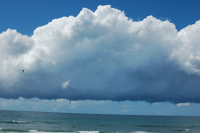
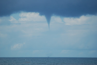
A waterspout is just a tornado over water, and tornadoes are swirling, upward-moving air. As I understand it, the sun heated the water and caused intense evaporation, then a cold air mass must have moved over it to cause the condensation. There must have been quite a temperature gradient to cause such intense uplift. Here's a closer shot of a typical funnel cloud... I hope the picture quality allows you to see the little disturbance at the ocean surface as well. Not a good place to be in a boat!
An odd feature we noted is the squared-off "notch" in the cloud on both sides of each funnel. This must indicate a region a little cooler, where the air reaches the condensation point a little earlier (lower). I assume it's circular (disk-shaped), I don't know if it's rotating or not. This may be a form of "wall cloud". You can see a disk around each funnel in the top photo. Also, the funnels seemed to be fairly evenly spaced, so there must be some relationship to the width of the thermals, like in a "cloud street".
Three or four of the funnel clouds stretched all the way to the surface, getting thinner as they went. If you look carefully, you can see that there's an empty core inside the dark tendril, I assume caused by centrifugal force. This shot came out well because of the blue sky behind the waterspout.
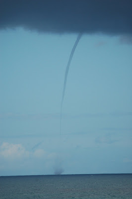
And here's a double shot:

We watched this activity for about 35 minutes. The waterspouts eventually died out as the storm moved to the north. The storm transitioned from the cumulus stage (uplifting) to the mature stage (collapsing into rain). I think the north part came ashore as the rain came down, and no waterspouts reached the land that we could see.
Yes, there can be lift over the ocean, but not the kind you'd want to fly in! This weekend we were camping at a Southern California beach, and a building thunderstorm went by about 2-3 miles offshore. This storm generated about 7 waterspouts that we could see! This picture shows four of them. (Click any pic for a larger, hi-res image.)

A waterspout is just a tornado over water, and tornadoes are swirling, upward-moving air. As I understand it, the sun heated the water and caused intense evaporation, then a cold air mass must have moved over it to cause the condensation. There must have been quite a temperature gradient to cause such intense uplift. Here's a closer shot of a typical funnel cloud... I hope the picture quality allows you to see the little disturbance at the ocean surface as well. Not a good place to be in a boat!
An odd feature we noted is the squared-off "notch" in the cloud on both sides of each funnel. This must indicate a region a little cooler, where the air reaches the condensation point a little earlier (lower). I assume it's circular (disk-shaped), I don't know if it's rotating or not. This may be a form of "wall cloud". You can see a disk around each funnel in the top photo. Also, the funnels seemed to be fairly evenly spaced, so there must be some relationship to the width of the thermals, like in a "cloud street".

Three or four of the funnel clouds stretched all the way to the surface, getting thinner as they went. If you look carefully, you can see that there's an empty core inside the dark tendril, I assume caused by centrifugal force. This shot came out well because of the blue sky behind the waterspout.

And here's a double shot:

We watched this activity for about 35 minutes. The waterspouts eventually died out as the storm moved to the north. The storm transitioned from the cumulus stage (uplifting) to the mature stage (collapsing into rain). I think the north part came ashore as the rain came down, and no waterspouts reached the land that we could see.
Saturday, September 08, 2007
Contest / cross-country / landout
Thursday: I did scout the landout sites as planned, all the way to Bishop, and updated my notes with exact mileages, road conditions, etc. A very long driving day! The distances and the terrain got me to thinking a lot and worrying more than I probably should. The route I chose is up the east side of the Sierra Nevada, with the Owens Valley just to the east. Experienced pilots go hundreds of miles this way, nearly every weekend. There are many airports, roads, dry lakes, and some fields all along the way, and most of them are within about 10 miles of the mountains (which are from 8000' to 14,000' MSL). So in theory, if you lose lift, you just leave the mountains and it's an easy glide to a landout spot because you're starting out quite high.
In practice, it doesn't always work that way because of sink or winds. You're not always adjacent to the spots, so you have an angled path which is a little longer. Last year, J had to land in a dirt patch halfway to California City due to heavy sink. Between the safe spots, there's a lot of rough ground. And some of the landouts are several miles down dirt roads, where my truck and the trailer could easily get stuck, so that makes me want to avoid them... which makes the distance between the good ones more challenging. Originally, I thought I was going to fly this with an instructor or experienced XC pilot, but that didn't work out. I've done 3 or 4 mountain / cross country flights, so I have some experience but not a lot. So I'll admit, it was making me nervous.
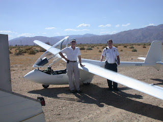
Friday: I had some prep work to do on the PW5. Somehow working with the aircraft itself makes me more comfortable with new challenges, so by the middle of the day I was feeling OK. But I did have a couple of equipment problems. I had bought a second Camelbak-type water pack, and it was leaking, which took some time to deal with. Then after I programmed the radio memories, hooked up the Volkslogger and PDA and tried uploading waypoints and a flight declaration, I started getting "low battery" warnings from the VL, and the Borgelt displayed 10 volts instead of the 12 it should have had. Long story short, after consulting some other pilots, I decided to fly with it. I have my handheld radio, a new clip-on miniature electronic variometer, my GPS to plug into my PDA, and my charts and info sheets. So I have backups for all the electrical stuff.
By the time I was done with all the prep work and problems, the wind had picked up to about 10-15kts from the south, making a stiff but inconstant crosswind. The PW5 does not do really well in crosswinds, and only one other glider launched the whole time I was there, so I decided to scrub for the day. I've flown in the area several times before.
Saturday morning I talked with L and a couple other pilots about conditions and routes. The weather turned out to be better than predicted, with the wind still out of the south but not too strong. Cumulus clouds started forming both over the Tehachapis and to the north about 10:30, so the launching started about 11:00. I launched at 12:20, let off in lift at 7700 MSL, and quickly got up to 9700 under a little cloud. But 20 minutes into the flight, "low battery" again! My PDA lost its data connection to the GPS but got it back again. As J predicted, the radio was the first to go, but the flight computer was working. I checked that I could reach N with my handheld, and told him I would not leave the valley... low battery this early in the flight was a bad thing.
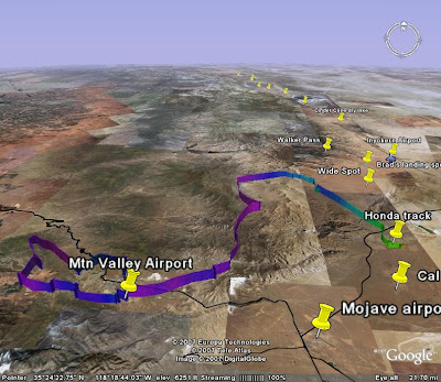
There were lots of CU, so I hopped around from cloud to cloud seeing how the lift was working. I frankly don't remember how strong it was, but getting up to 10,200 to 10,400 repeatedly was not a problem. Bigger CU to the north were looking promising. So I told N I would go to the east end of the valley and see how it worked. It was doing well, with short hops to the mountains to the north, and I could see California City airport and the Honda track (a good landout site) within gliding distance, so I told N I would head north with Honda track as my first landout option, and he headed out with the trailer. This was about an hour into the flight. The lift was working, and I was soon up to the middle of the Kelso valley... but on the west side, farther from the landout sites than I liked. The re were no CU over the eastern ridge. At some point I realized that I was depending on the CU, and thinking that there was no other lift. I now realize that was pessimistic, that there probably was dry "blue" lift in other areas.
The CU followed the western / central mountains, with nothing showing over the ridge that would keep me close to my landout sites. My computer and charts indicated I should be able to make Inyokern, so I headed that way and advised N. The farther I went, the less likely that appeared. Not heavy sink, but a little. With the Honda track visible and at a decent angle, and Inyokern not, I committed to land at the Honda track and recalled N.
As I headed that way, two things started to happen:
1. My glide slope started to deteriorate, and I was approaching a critical altitude that meant I might not make it. Later I figured out why: I had underestimated the effect of the headwind. It wasn't strong, but it was right at me.
2. My variometer went nuts! It was swinging wildly up and down. I finally concluded that the battery voltage was low enough that the vario was unreliable (and the B50 averager display). So I shut off the audio and turned on my micro vario. It's not very loud! (I had not flown with it before, although I have driven around with it a bit.) That faint beeping, and the seat of my pants, and my altimeter were now my clues to lift. And I was wondering whether the data feed from the ship's GPS to my PDA was reliable, with the voltage getting low. Switching to the plug-in GPS during flight is possible, but not desirable. There were no visual lift cues: no CU in the area, no birds, no other gliders, no dust devils (though I didn't really look down much). Well, there was one CU off to the right, but it was about 40 degrees off course, which I thought was too far. Fortunately I found a blue thermal and worked it up to 9300 MSL, which gave me the altitude I needed to no longer be worried about reaching my landing point. But until I found that thermal, I was really getting nervous, and was really busy checking altitudes and glide ratios and making decisions. There was one other landout spot between me and Honda track, a place know as Wide Spot, but it's not very big and is really for emergencies only.
Soon enough I was approaching my landout spot, and could see the truck and trailer waiting. I did not find any other significant lift on the way. That one thermal had done the trick: once I got over the track, I had about 2000' to lose. Go figure! And I found a little light lift right there, so I had to fly around a bit to lose altitude. This being my first off-field landing, I thought back to my XC training. Based on the wind direction (thanks to N on the ground!), and the presence of some power lines, I selected a landing direction, a distance from the "runway", and an Initial Point. (I've learned the TLAR method of approach planning, which does not depend on an altimeter or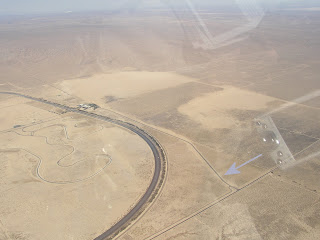 landmarks. If you want to know what TLAR stands for, contact me with a comment.) The "runway" is a road leading into the Honda test facility. It's a straight two-laner with *very* wide shoulders and no obstructions. I *assumed* it would be empty on a Saturday, but as I was about 200 feet above my pattern entry, a car entered the road. Fortunately I had some light lift and didn't need to land right that minute. After it cleared, another car came, and stopped to talk to N. It turned out to be a security guard, who would stay clear until I landed.
So I set up and landed. My approach was good, although I did get a little fast on late downwind. Touchdown was good, but with a crosswind I could not keep the ship rolling straight. Fortunately the airbrakes and wheel brake work well, and I only rolled off onto the shoulder a little ways. I kept the wings mostly level and did not touch a wing until I stopped. Whew! A good first off-field landing! (It would be good for me to learn to do a "wheel" landing in the PW5, holding off the nose wheel so I can steer on the ground. With a small rudder and fixed wheels, the PW5 on two wheels really does not turn.) Total flight time: 2:25. Total distance: 25 miles (since I turned back southeastward to land).
 The security guard took my information, and hung around while we packed up my gear and trailered the glider. He had told N that we were the second glider to land there today. He said they land there all the time - that's why Honda keeps the shoulders graded and cleared, though the're not thrilled. I could not get ConnectMe to download my flight trace from the Volkslogger, and I felt rushed with the guard hanging around, so I'll have to download it next time the glider is out of the trailer.
So... I have now done a semi-successful cross-country flight. It was not long enough for Silver distance, and probably not enough altitude gain for Silver altitude. I probably tied for last place in the Dust Devil Dash, unless someone went to Cal City or returned to Tehachapi.
(click the pic for a bigger view.)
Learnings:
In practice, it doesn't always work that way because of sink or winds. You're not always adjacent to the spots, so you have an angled path which is a little longer. Last year, J had to land in a dirt patch halfway to California City due to heavy sink. Between the safe spots, there's a lot of rough ground. And some of the landouts are several miles down dirt roads, where my truck and the trailer could easily get stuck, so that makes me want to avoid them... which makes the distance between the good ones more challenging. Originally, I thought I was going to fly this with an instructor or experienced XC pilot, but that didn't work out. I've done 3 or 4 mountain / cross country flights, so I have some experience but not a lot. So I'll admit, it was making me nervous.
Friday: I had some prep work to do on the PW5. Somehow working with the aircraft itself makes me more comfortable with new challenges, so by the middle of the day I was feeling OK. But I did have a couple of equipment problems. I had bought a second Camelbak-type water pack, and it was leaking, which took some time to deal with. Then after I programmed the radio memories, hooked up the Volkslogger and PDA and tried uploading waypoints and a flight declaration, I started getting "low battery" warnings from the VL, and the Borgelt displayed 10 volts instead of the 12 it should have had. Long story short, after consulting some other pilots, I decided to fly with it. I have my handheld radio, a new clip-on miniature electronic variometer, my GPS to plug into my PDA, and my charts and info sheets. So I have backups for all the electrical stuff.
By the time I was done with all the prep work and problems, the wind had picked up to about 10-15kts from the south, making a stiff but inconstant crosswind. The PW5 does not do really well in crosswinds, and only one other glider launched the whole time I was there, so I decided to scrub for the day. I've flown in the area several times before.
Saturday morning I talked with L and a couple other pilots about conditions and routes. The weather turned out to be better than predicted, with the wind still out of the south but not too strong. Cumulus clouds started forming both over the Tehachapis and to the north about 10:30, so the launching started about 11:00. I launched at 12:20, let off in lift at 7700 MSL, and quickly got up to 9700 under a little cloud. But 20 minutes into the flight, "low battery" again! My PDA lost its data connection to the GPS but got it back again. As J predicted, the radio was the first to go, but the flight computer was working. I checked that I could reach N with my handheld, and told him I would not leave the valley... low battery this early in the flight was a bad thing.
There were lots of CU, so I hopped around from cloud to cloud seeing how the lift was working. I frankly don't remember how strong it was, but getting up to 10,200 to 10,400 repeatedly was not a problem. Bigger CU to the north were looking promising. So I told N I would go to the east end of the valley and see how it worked. It was doing well, with short hops to the mountains to the north, and I could see California City airport and the Honda track (a good landout site) within gliding distance, so I told N I would head north with Honda track as my first landout option, and he headed out with the trailer. This was about an hour into the flight. The lift was working, and I was soon up to the middle of the Kelso valley... but on the west side, farther from the landout sites than I liked. The
 re were no CU over the eastern ridge. At some point I realized that I was depending on the CU, and thinking that there was no other lift. I now realize that was pessimistic, that there probably was dry "blue" lift in other areas.
The CU followed the western / central mountains, with nothing showing over the ridge that would keep me close to my landout sites. My computer and charts indicated I should be able to make Inyokern, so I headed that way and advised N. The farther I went, the less likely that appeared. Not heavy sink, but a little. With the Honda track visible and at a decent angle, and Inyokern not, I committed to land at the Honda track and recalled N.
As I headed that way, two things started to happen:
1. My glide slope started to deteriorate, and I was approaching a critical altitude that meant I might not make it. Later I figured out why: I had underestimated the effect of the headwind. It wasn't strong, but it was right at me.
2. My variometer went nuts! It was swinging wildly up and down. I finally concluded that the battery voltage was low enough that the vario was unreliable (and the B50 averager display). So I shut off the audio and turned on my micro vario. It's not very loud! (I had not flown with it before, although I have driven around with it a bit.) That faint beeping, and the seat of my pants, and my altimeter were now my clues to lift. And I was wondering whether the data feed from the ship's GPS to my PDA was reliable, with the voltage getting low. Switching to the plug-in GPS during flight is possible, but not desirable. There were no visual lift cues: no CU in the area, no birds, no other gliders, no dust devils (though I didn't really look down much). Well, there was one CU off to the right, but it was about 40 degrees off course, which I thought was too far. Fortunately I found a blue thermal and worked it up to 9300 MSL, which gave me the altitude I needed to no longer be worried about reaching my landing point. But until I found that thermal, I was really getting nervous, and was really busy checking altitudes and glide ratios and making decisions. There was one other landout spot between me and Honda track, a place know as Wide Spot, but it's not very big and is really for emergencies only.
Soon enough I was approaching my landout spot, and could see the truck and trailer waiting. I did not find any other significant lift on the way. That one thermal had done the trick: once I got over the track, I had about 2000' to lose. Go figure! And I found a little light lift right there, so I had to fly around a bit to lose altitude. This being my first off-field landing, I thought back to my XC training. Based on the wind direction (thanks to N on the ground!), and the presence of some power lines, I selected a landing direction, a distance from the "runway", and an Initial Point. (I've learned the TLAR method of approach planning, which does not depend on an altimeter or
 landmarks. If you want to know what TLAR stands for, contact me with a comment.) The "runway" is a road leading into the Honda test facility. It's a straight two-laner with *very* wide shoulders and no obstructions. I *assumed* it would be empty on a Saturday, but as I was about 200 feet above my pattern entry, a car entered the road. Fortunately I had some light lift and didn't need to land right that minute. After it cleared, another car came, and stopped to talk to N. It turned out to be a security guard, who would stay clear until I landed.
So I set up and landed. My approach was good, although I did get a little fast on late downwind. Touchdown was good, but with a crosswind I could not keep the ship rolling straight. Fortunately the airbrakes and wheel brake work well, and I only rolled off onto the shoulder a little ways. I kept the wings mostly level and did not touch a wing until I stopped. Whew! A good first off-field landing! (It would be good for me to learn to do a "wheel" landing in the PW5, holding off the nose wheel so I can steer on the ground. With a small rudder and fixed wheels, the PW5 on two wheels really does not turn.) Total flight time: 2:25. Total distance: 25 miles (since I turned back southeastward to land).
 The security guard took my information, and hung around while we packed up my gear and trailered the glider. He had told N that we were the second glider to land there today. He said they land there all the time - that's why Honda keeps the shoulders graded and cleared, though the're not thrilled. I could not get ConnectMe to download my flight trace from the Volkslogger, and I felt rushed with the guard hanging around, so I'll have to download it next time the glider is out of the trailer.
So... I have now done a semi-successful cross-country flight. It was not long enough for Silver distance, and probably not enough altitude gain for Silver altitude. I probably tied for last place in the Dust Devil Dash, unless someone went to Cal City or returned to Tehachapi.

Learnings:
- Preparations pay off. I had information with me about the location and altitude of my landout spots.
- Visual navigation in unfamiliar terrain is tough. Even after previewing some of the areas on Google Earth, things look different.
- Backup devices are important! I used them! (Some would suggest I rely too much on the electronic navigation... probably true, but I don't fly often enough in that area to know my way around.)
Whew! That's a long post! I hope you find it helpful... I needed to write it.
Subscribe to:
Posts (Atom)