Showing posts with label Trace. Show all posts

Sunday, July 15, 2012

Friday the 13th? Bah! But still....

I read quite a few publications about flying, not just soaring, because I want to be the best pilot I can be.  It's frequently stated that many accidents come about not because of a catastrophic event, but because of a "chain" of things that lead to a bad situation or bad decision. These things can be actual problems, or issues that stay on the pilot's mind and cause distractions. I try to be very self-aware and keep an eye out for multiple things going wrong. Many of these are just normal things that crop up during flight planning and prep, but some days more of them happen than usual. That doesn't necessarily mean I won't fly, but it makes my "spidey-sense" go on high alert and make sure I'm being extra careful.

I'm not superstitious, but this series of unfortunate events started the night of Friday the 13th.
  • I thought I was going to have a passenger going for an intro flight on Saturday. That's fine, I like giving rides. He was on and off all evening. He wouldn't get to the gliderport until noon, which meant no smooth early ride, and possibly waiting in line for a towplane if we took off during prime time. It doesn't really make much difference, but it meant I needed to think about which plane to prep, what time to fly, whether anyone else would need the 2-seater, etc.
  • I found that my PDA (an old HP iPAQ) had lost its memory. That's happened a few times before, usually due to failure to charge the battery in time. But this time the battery and charger were OK, so it's unexplained. Because I have changed computers since the last time this happened, I had to mess around a bit to get the programs and files installed, rather than running a simple restore. And then had to test the GPS to make sure it was working. This took well into the late hours of the evening.
Saturday, before flying, stuff kept happening:
  • I got a text message that the passenger had decided not to go. The message was from 2:30 in the morning. So I'm wondering: what's up with that? Oh well, at least I'll get to fly the PW5, which is easier to prep and simpler to fly on what was looking to be a good thermal day.
  • During the preflight inspection, an issue came up with the PW5. I won't go into it here, but it caused me some delay and concern as I had to walk around and search both ships and both trailers, and contact the most recent pilot to ask about it. His phone number had changed, but I contacted him by text message and later talked to him. More extra tasks and delay and distraction.
  • I usually use my own O2 tank with the PW5's electronic system. Once before, and again today, I could not get the PW5's screw-on connector to seal right, which means O2 leaks out. Probably we need to replace the O-ring again. After trying for quite a while, I decided to use my own Oxymiser system, which means removing the PW5's box and tubing. That's pretty simple, but it does mean using a manual flow control instead having the automatic system come on at 10,000 feet.
  • I started up my PDA/GPS and it got a good fix. Whew! Last time it didn't, and I didn't get a flight trace. But a few minutes later it popped up the screen demanding the license key (since I had reinstalled SeeYou Mobile last night). Fortunately I have that key in a text file on the device. Unfortunately cut-n-paste wouldn't work, so I had to write down and enter the key manually. Just another annoyance... in 90+ degree heat...
I nearly always take a break after the inspection and prep, have my light lunch, cool down, and then go fly. When I get back to the ship, there are always a few final items to take care of, because I don't like to put certain things into the cockpit because they get hot. When I was nearly ready, I found I needed to make yet another trip back to the "pilot's lounge". On the walk back to the plane I reviewed all the distractions and delays, and decided that they had not accumulated into anything that would keep me from flying. As I mentioned, I'm aware of cumulative distractions, but all these items had been resolved, so I put them out of my mind and focused for the flight. The CU's had been popping since 9:00 but were not overdeveloping, so it looked to be a good day. I took off at 12:45.
Stuff kept happening:
  • During the tow, the red emergency canopy release handle fell off. Just fell off! I ignored it and focused on the tow, which is a critical part of the flight. I didn't need to be feeling around my feet looking for it while flying formation! Later in the flight, I found that it had nicely landed on the pedestal within easy reach, and it simply screwed back on.
  • Once I started thermaling, I noticed that the "thermal analyzer" function of SeeYou was not activating. That made me wonder what other settings might not be set the way I wanted, but nothing else arose during the flight.
  • I received a pulse oximeter for Christmas, but had only tried it once before in flight. This time I tried it again, but I could not see the display and put it away. Later on the ground I saw that it was not detecting my finger. I tried it later at home and it worked fine. Maybe I didn't put it on right, or maybe it got overheated? Another distraction...
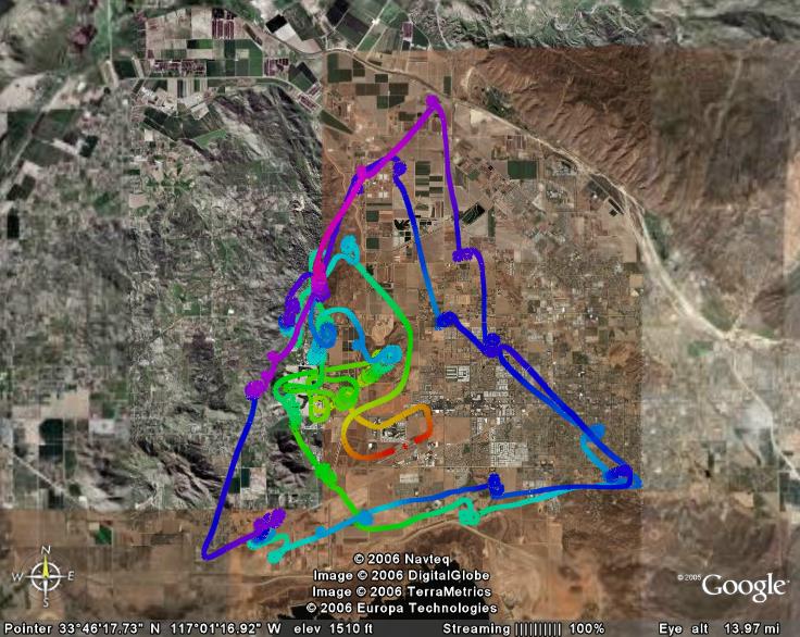
All that aside, it turned out to be an outstanding day for soaring! I let off tow in lift and never lost it. Very quickly I got up to 10,000' MSL and never went below that altitude until it was time to come home. Most of the time I was above 11,000, and my max was 12,776. 

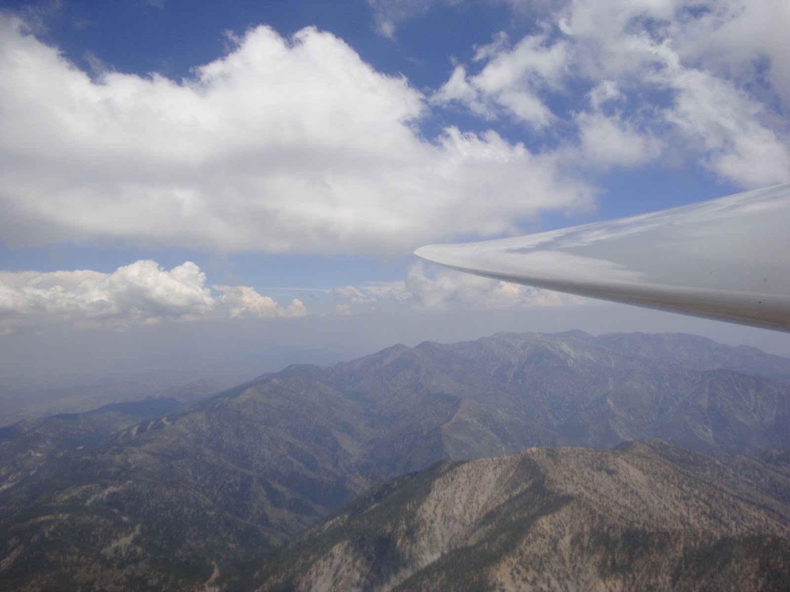
The CU's coming off the northern edge of the mountains were abundant, close enough to nearly form "cloud streets" at times. 
The lift was turbulent, though, with lots of ups and downs. This flight trace is color-coded by vertical speed. It's really rare to see the lift and sink so interleaved. 

The CU were not big or strong enough to overdevelop into thunderstorms in this region. I could see to the east that there was a whole north-south line of bigger CU. In the picture you can see that it's hazy brown below the cloudbase, and clear above. (Click on the pic for a better look.) I think there was a convergence of air masses triggering those CU's, different from the ones where I was which seemed to be thermally generated.

And the lift was not just under the clouds, I found lift between them that allowed me to go higher than the cloudbase. This was probably the best thermal lift day I've experienced since coming to Crystal. I didn't really go very far - I've written before about the limitations of flying club planes - but I did go further west and north than I ever have. Someday I'll map out a local cross-country triangle and do some goal-oriented flights. For now I'm just having great fun cloud-hopping at 12,000 feet!
I also went north over the desert and continued to find lift to 10 thousand feet. I flew for nearly two and a half hours. It would not have been a good day for my passenger's intro flight - we would have had to start much earlier in the day when it was not so turbulent.

Sunday, November 06, 2011

Dual Flight over Early Snow


Friday brought a fast-moving cold storm to Southern California. Saturday looked to be clear skies and cool aloft with possible thermals to 9 or 10,000 feet, but also possibly windy to 15 knots, with the wind maybe too westerly to make good wave. As I was driving to the airport another pilot called and we talked about sharing a flight, so I prepped our Grob 103. It's the better ship to be in if the winds get strong, but its oxygen tank is out for repair, so I knew we couldn't go too high if the wave was working. We needed to do several items of maintenance, but that gave us some time to get early flight reports from a couple of other pilots. It sounded like a high tow over the mountains might be the only way to fly today, so I was glad to be splitting the tow fee.


There were lenticular clouds to the north, but way too far away to be useful... that's common at Crystal.


The wind was from the west but not very strong, 5 knots most of the time. There was obviously a gentle south wind coming over the mountains, pushing clouds over the rim into the desert as you can see in the picture. And we were told there was an east wind aloft, so ridge lift on the east side of Mt. Lewis was a possibility. And with the clear air, thermals might pop too. So... the air was in a lot of motion today - what would we find?

I took the rear seat, and G as PIC took the front. He said he had not had much experience with wave or ridge soaring, so he thought maybe I'd do much of the flying and he'd to the takeoff and landing. Fine with me. I took myPDA/GPS device hoping to get a trace of our flight. As we were pushing out to the runway, a cigar-shaped lenticular cloud formed right between us and the mountain, so smooth wave was happening. But by the time we took off, it was gone.


Another pilot reported that the rumored ridge lift on Mt. Lewis was not working, and the spillover clouds were really getting thick, so we let off at 8500' kind of in front of the mountain and went looking for ridge lift in various places. G didn't find anything so after a while he turned it over to me. I had seen some raggedy little clouds in a rough SW-NE line that I thought might be weak rotor clouds, but there was no real lift next to them.

So on the theory that the west wind might be making ridge lift or weak wave, I tried a north-south line over the low end of the Second Ridge. I did find some narrow lift and was able to work up in it through several back-and-forth passes. I tried to keep my lines tight in case it was a narrow band, and that seemed to work. The picture (click to expand) shows a trace of that portion of the flight. It was not smooth enough to be wave, and there was no obvious north-south ridge to be making orographic lift, so what was it? I thought maybe the nose of the Second Ridge was creating what they call "bow wave", but the wind wasn't really strong enough for that. It didn't last long, but I gained 1,000', so we had time to fly around.

Didn't find much after that, and eventually got low enough over the ridges that I decided to head toward a weak little lenticular could that was perched over the airport. I found neither good lift nor good sink on the way, and by the time we got there the lennie had disappeared. I gave the plane back to G and he went in search of thermal lift on the way back to the landing pattern. There may have been a little, but it was pretty weak and not working.

There were a few other odd little lennies to the west, but too far for us to reach. We came in for a landing after 51 minutes. The surface wind was still from the west and only about 5 knots, so it had never really picked up.

We had seen a glider above us and later below us when we were working the one area of mysterious lift. Back on the ground, instructor D asked, if that was us he saw, and commented that the shear line had been good but had disappeared as we worked it. Then the light went on! The wind from the south over the mountain, and the wind from the west, were colliding and going up. It wasn't ridge, or wave, or "bow wave", or thermal - it was convergence! I'm gonna need a checklist just for all the different kinds of lift we find in the chaotic environment over the mountains!

Sunday, April 17, 2011

Flight trace video of my wave flight

I sometimes record traces of my flights with the SeeYou Mobile program running on an iPaq. I then play them back on the SeeYou PC program to study how things went. I've recorded a playback of my April 2 wave flight and posted it on YouTube - first time I've figured out how to do that. It's played back at 10 times the actual speed, so my 2 hour and 20 minute flight plays back in 14 minutes. Here's the link.

If you just want to see the time when I really connected with the lift and started climbing at a good rate, go to 8:05 through 11:42 in the movie (which is about 13:42 to 14:18 on the flight clock).

Saturday, April 02, 2011

Great First Solo Wave Flight

Today a weak front was causing a southwest-to-northeast flow, which made for mountain wave conditions at Crystalaire - the first day it's actually been working since the day of my site intro flight. There were monster wave clouds, closer to the airport than I had seen before, probably too high to be of use to us, but indicating good wave action. As I was prepping the PW5, Dale (very experienced instructor) came over to give me some advice on how to fly the wave today. That was nice - I was going to seek him out! He thought it was weakening today and not likely to go over about 8,000 to 9,000 feet, with maybe some thermal lift later in the day if the cloud cover was not too thick.
I took off at 12:20 and we towed through rotor on the way to wave lift. A high tow was necessary to get there, and I let off at about 8,500 MSL when the rotor abruptly quit. I was immediately in weak to moderate wave lift. I worked it for a while, trying the areas where people had said it had been working a little while ago. I found up to about 3.3 knots of lift in the beginning. I gained some, lost some, in it sometimes, in sink sometimes - worked between 6,700 and 8,800 for quite a while, feeling it out and trying to figure out exactly where it was. Every time I got back into a little rotor, I headed back upwind and found wave lift. It wasn't very wide, so I had to go back and forth in a fairly narrow "sweet spot". A couple times I found *heavy* sink as I got too close to the mountain, as expected (since the wind was "spilling" downslope before it bounced back up again).

A couple times I decided to head back to the flatlands, and when I went over the "second ridge" I contacted even stronger lift. At times it was up to 7.7 knots! (Later I was reminded that the waves tend to move downwind over time.) I finally got smart and realized I needed to turn back sharply when the lift started to weaken, so I could get right back to the good stuff. This worked really well, and I worked it up... and up... topping out at 10,200 feet. Another pilot worked it from 10 up to 11 while I was there, and Dale got to 14!


In this flight trace, the later part is in the upper left, and you can see how much tighter I was making my back-and-forth passes.

(Click on the image to see the full-sized picture.)


As many people have said, the lift in the wave is incredibly smooth. At times there's almost no sensation of motion if you're headed into the wind. In this next trace, the line color shows groundspeed. There were times when my GS was as little as 17 knots.


After about two hours I decided to come down. On the way back to the airport I continued to find lift up to 10,200, but also some pretty hard rotor. I eventually pulled 1/3 spoilers and turned lots of circles to get down. The lift was so strong and easy to find I could have stayed up a long time.

Approach and landing were challenging. I called in for a wind report, and was told it was from the southeast at 15 with stronger gusts, so I chose to land on runway 7 (to the east). On the way into the pattern I continued to get battered by turbulence, a couple of those big bumps that knock everything around in the cockpit and lift you out of the seat even with the belts tight. On short final I got a couple more fairly hard bumps. I carried some extra speed due to the expected headwind component, so I was able to control it pretty well, but once I got down low I put it down as soon as I could - no floating in ground effect - I wanted to be on the ground! Once I started to slow down a bit, I found out how strong that crosswind really was. It turned me about 45 degrees to the right and off the runway. (The PW5 has a decent sized tail but a tiny rudder, so crosswinds really push it around.) I applied full spoilers and wheel brake and stopped just a few feet to the side of the runway.My wings were level, or I should say right wing down a bit because of the crosswind, so I don't think I even came close to touching a wing. But it sure turned me!

Later the fellow who gave me the wind check said that although the wind sock showed it to be from the southeast, when he stepped outside a few minutes later he saw how cross it was. By that time I was committed to 7. Some other folks pointed out that there is a dirt crosswind runway which would have been much more into the wind, and in fact someone landed on it moments later.

So although I landed safely, I learned two big lessons:
  1. Even with a wind report from the ground, make sure to look at the wind socks or tetrahedron for confirmation. I was approaching the field perpendicularly, so I knew by the time I could see the socks I would be really close and need to commit to a direction, so I relied on the report. And I was dealing with a lot of turbulence and a strong headwind, so I really didn't plan for or have enough altitude to overfly the field.
  2. Know all of the resources available. Even if I had known how cross the wind was, I really had not thought about the value of that other dirt runway. I chose between 7 and 25 based on the wind direction, but I did have another option which would have been better.
My flight was 2 hours and 20 minutes, and up to 10,200 feet MSL. Not bad for my first day of surfing the mountain wave.

Saturday, September 08, 2007

Contest / cross-country / landout

Thursday: I did scout the landout sites as planned, all the way to Bishop, and updated my notes with exact mileages, road conditions, etc. A very long driving day! The distances and the terrain got me to thinking a lot and worrying more than I probably should. The route I chose is up the east side of the Sierra Nevada, with the Owens Valley just to the east. Experienced pilots go hundreds of miles this way, nearly every weekend. There are many airports, roads, dry lakes, and some fields all along the way, and most of them are within about 10 miles of the mountains (which are from 8000' to 14,000' MSL). So in theory, if you lose lift, you just leave the mountains and it's an easy glide to a landout spot because you're starting out quite high.

In practice, it doesn't always work that way because of sink or winds. You're not always adjacent to the spots, so you have an angled path which is a little longer. Last year, J had to land in a dirt patch halfway to California City due to heavy sink. Between the safe spots, there's a lot of rough ground. And some of the landouts are several miles down dirt roads, where my truck and the trailer could easily get stuck, so that makes me want to avoid them... which makes the distance between the good ones more challenging. Originally, I thought I was going to fly this with an instructor or experienced XC pilot, but that didn't work out. I've done 3 or 4 mountain / cross country flights, so I have some experience but not a lot. So I'll admit, it was making me nervous.

Friday: I had some prep work to do on the PW5. Somehow working with the aircraft itself makes me more comfortable with new challenges, so by the middle of the day I was feeling OK. But I did have a couple of equipment problems. I had bought a second Camelbak-type water pack, and it was leaking, which took some time to deal with. Then after I programmed the radio memories, hooked up the Volkslogger and PDA and tried uploading waypoints and a flight declaration, I started getting "low battery" warnings from the VL, and the Borgelt displayed 10 volts instead of the 12 it should have had. Long story short, after consulting some other pilots, I decided to fly with it. I have my handheld radio, a new clip-on miniature electronic variometer, my GPS to plug into my PDA, and my charts and info sheets. So I have backups for all the electrical stuff.

By the time I was done with all the prep work and problems, the wind had picked up to about 10-15kts from the south, making a stiff but inconstant crosswind. The PW5 does not do really well in crosswinds, and only one other glider launched the whole time I was there, so I decided to scrub for the day. I've flown in the area several times before.

Saturday morning I talked with L and a couple other pilots about conditions and routes. The weather turned out to be better than predicted, with the wind still out of the south but not too strong. Cumulus clouds started forming both over the Tehachapis and to the north about 10:30, so the launching started about 11:00. I launched at 12:20, let off in lift at 7700 MSL, and quickly got up to 9700 under a little cloud. But 20 minutes into the flight, "low battery" again! My PDA lost its data connection to the GPS but got it back again. As J predicted, the radio was the first to go, but the flight computer was working. I checked that I could reach N with my handheld, and told him I would not leave the valley... low battery this early in the flight was a bad thing.

There were lots of CU, so I hopped around from cloud to cloud seeing how the lift was working. I frankly don't remember how strong it was, but getting up to 10,200 to 10,400 repeatedly was not a problem. Bigger CU to the north were looking promising. So I told N I would go to the east end of the valley and see how it worked. It was doing well, with short hops to the mountains to the north, and I could see California City airport and the Honda track (a good landout site) within gliding distance, so I told N I would head north with Honda track as my first landout option, and he headed out with the trailer. This was about an hour into the flight. The lift was working, and I was soon up to the middle of the Kelso valley... but on the west side, farther from the landout sites than I liked. There were no CU over the eastern ridge. At some point I realized that I was depending on the CU, and thinking that there was no other lift. I now realize that was pessimistic, that there probably was dry "blue" lift in other areas.

The CU followed the western / central mountains, with nothing showing over the ridge that would keep me close to my landout sites. My computer and charts indicated I should be able to make Inyokern, so I headed that way and advised N. The farther I went, the less likely that appeared. Not heavy sink, but a little. With the Honda track visible and at a decent angle, and Inyokern not, I committed to land at the Honda track and recalled N.

As I headed that way, two things started to happen:

1. My glide slope started to deteriorate, and I was approaching a critical altitude that meant I might not make it. Later I figured out why: I had underestimated the effect of the headwind. It wasn't strong, but it was right at me.

2. My variometer went nuts! It was swinging wildly up and down. I finally concluded that the battery voltage was low enough that the vario was unreliable (and the B50 averager display). So I shut off the audio and turned on my micro vario. It's not very loud! (I had not flown with it before, although I have driven around with it a bit.) That faint beeping, and the seat of my pants, and my altimeter were now my clues to lift. And I was wondering whether the data feed from the ship's GPS to my PDA was reliable, with the voltage getting low. Switching to the plug-in GPS during flight is possible, but not desirable. There were no visual lift cues: no CU in the area, no birds, no other gliders, no dust devils (though I didn't really look down much). Well, there was one CU off to the right, but it was about 40 degrees off course, which I thought was too far. Fortunately I found a blue thermal and worked it up to 9300 MSL, which gave me the altitude I needed to no longer be worried about reaching my landing point. But until I found that thermal, I was really getting nervous, and was really busy checking altitudes and glide ratios and making decisions. There was one other landout spot between me and Honda track, a place know as Wide Spot, but it's not very big and is really for emergencies only.

Soon enough I was approaching my landout spot, and could see the truck and trailer waiting. I did not find any other significant lift on the way. That one thermal had done the trick: once I got over the track, I had about 2000' to lose. Go figure! And I found a little light lift right there, so I had to fly around a bit to lose altitude. This being my first off-field landing, I thought back to my XC training. Based on the wind direction (thanks to N on the ground!), and the presence of some power lines, I selected a landing direction, a distance from the "runway", and an Initial Point. (I've learned the TLAR method of approach planning, which does not depend on an altimeter or landmarks. If you want to know what TLAR stands for, contact me with a comment.) The "runway" is a road leading into the Honda test facility. It's a straight two-laner with *very* wide shoulders and no obstructions. I *assumed* it would be empty on a Saturday, but as I was about 200 feet above my pattern entry, a car entered the road. Fortunately I had some light lift and didn't need to land right that minute. After it cleared, another car came, and stopped to talk to N. It turned out to be a security guard, who would stay clear until I landed.

So I set up and landed. My approach was good, although I did get a little fast on late downwind. Touchdown was good, but with a crosswind I could not keep the ship rolling straight. Fortunately the airbrakes and wheel brake work well, and I only rolled off onto the shoulder a little ways. I kept the wings mostly level and did not touch a wing until I stopped. Whew! A good first off-field landing! (It would be good for me to learn to do a "wheel" landing in the PW5, holding off the nose wheel so I can steer on the ground. With a small rudder and fixed wheels, the PW5 on two wheels really does not turn.) Total flight time: 2:25. Total distance: 25 miles (since I turned back southeastward to land).

The security guard took my information, and hung around while we packed up my gear and trailered the glider. He had told N that we were the second glider to land there today. He said they land there all the time - that's why Honda keeps the shoulders graded and cleared, though the're not thrilled. I could not get ConnectMe to download my flight trace from the Volkslogger, and I felt rushed with the guard hanging around, so I'll have to download it next time the glider is out of the trailer.

So... I have now done a semi-successful cross-country flight. It was not long enough for Silver distance, and probably not enough altitude gain for Silver altitude. I probably tied for last place in the Dust Devil Dash, unless someone went to Cal City or returned to Tehachapi.


(click the pic for a bigger view.)
Learnings:
  • Preparations pay off. I had information with me about the location and altitude of my landout spots.
  • Visual navigation in unfamiliar terrain is tough. Even after previewing some of the areas on Google Earth, things look different.
  • Backup devices are important! I used them! (Some would suggest I rely too much on the electronic navigation... probably true, but I don't fly often enough in that area to know my way around.)
I'll have to think on this a while to decide whether the challenge and accomplishment are worth the pre-flight and in-flight stress. I *really* don't want to land out in a location that is tough to get the trailer to, or in a rough desert area. I know, some people do this all the time... and have something to prove. I like to fly for fun, and parts of this flight were definitely not fun. But I probably *do* need to do a certain amount of XC since I want to be an instructor. I do feel good about working through the problems that I encountered in flight.
Whew! That's a long post! I hope you find it helpful... I needed to write it.

Saturday, June 03, 2006

Longest flight so far!

Today the soaring forecast was dismal: 150 fpm, due to very warm air aloft and a 5000' thick inversion. But the forecast turned out to be wrong. The ground temperature cranked up to 106 degrees, and apparently that was enough to punch through the inversion, or it lifted, or something. Some of us were able to get up over 6000' MSL. I found 2-4 kt lift all over the Hemet valley!

I was able to complete the "cross-country practice triangle" that I've been working on. It's three legs of about 16-17 mile each, but centered on the HMT gliderport so you're never too far away. I found lift two or three times on each leg, so it pretty well simulated the requirements of a cross-country flight. I did it one and 2/3 times, for a total of about 80 linear miles. Her's the flight trace:


This was one of the few flights I've had where I got high right away and then was able to stay within a lift band, so I was rarely desperate for altitude. Thermals were plentiful enough that I could finally spend some time practicing different centering and searching techniques I've been studying... usually I'm scratching for any lift I can find.

I was almost done at about 1:45... so close to the two hours! But near the airport, with about 200' to go before having to enter the pattern, I found a decent thermal that took me back up to 4500' or so, taking me to the 2-hour mark. I used up all my water and was getting pretty hot and tired, so I brought it down for a 2:17 total. That's one of the two 2-hour flights I need for my Bronze badge!

I intentionally took the Grob so I could get current in it again. I will probably take some passengers up soon, and wanted to be safe in it. No problem - I really enjoy flying it, although it does take a LOT of rudder rolling into turns. I think the long wings make it easier to catch thermals than in the little PW5.